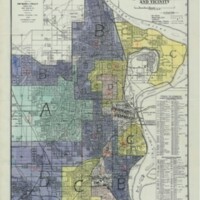
Omaha HOLC Map 1937
Dublin Core
Title
Omaha HOLC Map 1937
Subject
Redlining Map of Omaha by the Home Owners Loan Coporation
Description
In 1937, the Home Owners Loan Corporation published a map of Omaha that is attached below. This map was created by the HOLC to outline various areas in Omaha. The map was created to distinguish areas of Omaha based upon housing stock, sales, rental capacity, and terrain. Additionally, the grades on this map indicated by letters and color coding were based upon race and class. This map promoted investments in areas of West Omaha, and it enforced poverty and segregation in parts of North and East Omaha. This inevitability led to the history of segregation in Omaha, which played a role in black communities being disproportionately affected by lead poisoning. While this map was not directly a map from the City of Omaha as a designated City Planning Map, it made major implications on how the Home Owners Loan Corporation decided to design their map. Not only did the city plans prior to the HOLC Map have implications on the design of the map, but the loan map made implications on future developments within city planning (Davis, 2002).
As previously discussed, the early city planning efforts within Omaha were largely elitist. Instead of focusing on urban planning within already developed parts of Omaha, such as North and South Omaha, funding efforts within city planning were pushed to be directed towards new development within suburban areas of Omaha.
City plans during the 1920’s and early 1930’s continually made efforts to invest in suburban neighborhoods rather than central urban areas of Omaha. This inevitably led to the Home Owners Loan Corporation’s “redlining map” in 1937. This map was created by the HOLC to outline various areas in Omaha. The map was created to distinguish areas of Omaha based upon housing stock, sales, rental capacity, and terrain. Additionally, the grades on this map indicated by letters and color coding were based upon race and class. This map promoted investments in areas of West Omaha, and it enforced poverty and segregation in parts of North and East Omaha. The map was based upon current investments and demographics within these areas, which were largely impacted by city plans (Davis, 2002).
The HOLC Map of Omaha in 1937 signified which areas contained minorities, who were deemed as “high risk” subjects to receive loans. Many people of color were turned down by the bank for loans, making it impossible to move out of the impoverished neighbors and housing they were already living in. This map inevitably led to the reinforcement of segregation in Omaha, making it impossible for black individuals and families to move out of North Omaha. As segregation became more and more prevalent, the future urban planning goals continued to be directed towards investing in the development of new suburban communities, which black people never had the opportunity to be a part of due the HOLC Map (Daly, 2013).
The HOLC Map and its effects resulted in black communities being disproportionately affected by exposure to lead poisoning. City planning and redlining in Omaha have a continuous relationship with one another. While early city plans invested money in suburban Omaha, the HOLC mirrored this trend. And because the HOLC Map reinforced segregation and white flight to the suburbs, future city plans of Omaha continued the development of these suburbs.
Creator
Home Owners Loan Coporation
Publisher
North Omaha Information Support Everyone
Contributor
Cate Begley
Still Image Item Type Metadata
Original Format
Map
Citation
Home Owners Loan Coporation , “Omaha HOLC Map 1937,” History of Environmental Inequalities, accessed May 2, 2024, https://steppingintothemap.com/inequalities/items/show/216.
Embed
Copy the code below into your web page
