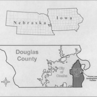
OLS locator map
Dublin Core
Title
OLS locator map
Subject
Omaha, Lead, Superfund Site
Description
The map on page 55 of the Final Record of Decision
showing the superfund site in relation to the greater state of Nebraska and Iowa
showing the superfund site in relation to the greater state of Nebraska and Iowa
Creator
U.S. Environmental Protection Agency
Source
EPA Public Information Center (North and South), Omaha Public Library, Washington Branch Library, South Omaha Library, EPA Region 7 Records Center
Publisher
EPA
Date
May 2009
Citation
U.S. Environmental Protection Agency, “OLS locator map,” History of Environmental Inequalities, accessed September 19, 2024, https://steppingintothemap.com/inequalities/items/show/155.
Embed
Copy the code below into your web page
