
Weekly Student Blog Instructions
Purpose: Maps are primary sources. They offer viewers glimpses of historic landscapes, of visible (and invisible) features of the world surrounding us, and they document how those elements have changed over time. Historians often use maps to illustrate their narratives and orient their readers to unfamiliar times and places. Maps offer much more to historians than illustration, however. Mapmakers’ decisions reflect their own “worldviews,” i.e. their cultural, social, and economic priorities. Maps are selective mirrors that often reflect as much about the culture that produced them as the environments they depict. In both respects, maps equal (and often surpass) textual sources in the depth of information potentially available to historians. These weekly blogs are opportunities for students to critically examine maps as primary sources.
Expectations: Each week, you will be responsible for submitting a thoughtful analysis of maps. Your blogs should be concise (no more than 400 words) and will address two primary subjects 1. A formal analysis of the work(s) 2. An insightful discussion of the work in the context of course material (discursive analysis). These short essays must be posted to the blog using the tag “Student Weekly Posts” before the beginning of class on the Monday of the week they are listed in the syllabus because they will form the core of our discussion. 400 words is NOT enough space to cover ALL of the questions, so choose one question or subject to focus your discussion on – making reference to other analysis questions when they are relevant.
You are expected to use images (i.e. screenshots of map details, other maps, etc) in your blog submissions.
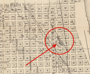
Here is a point I’m making by showing the detail of Omaha City, Nebraska. Oscar F. Davis, 1866. Courtesy David Rumsey.com.
Questions to guide your analysis:
Formal analysis of the work:
- Type: Topographic/Thematic/Reference/Other, or a mix?
- Layout: How do the non-cartographic elements of the map aid or detract from the clarity and purpose of the map?
- Carto-graphics: How do the graphic elements of data (symbology, projection, choice of color, scale, extent) further the goals of the map?
Discursive analysis
- Author – Who created this map?
- Audience – who was this map created for?
- Subject – What does this map depict?
- Arguments – What is the proposition, argument, or message of this map?
- Time – When is this map? Does it depict change over time? Multiple timelines? Is it timeless?
- Questions: How might the map be adapted to more effectively convey its message?
The MOST effective blogs will not answer these questions, one after the other. It will hone in on one discursive theme that you want to explore in depth and use the formal analysis to aid your argument.
Embedding an ArcGIS Story on a WordPress Site
To embed your story on your WordPress Site:
- Click on the link icon at the top of the screen to copy the URL for your StoryMap
- Open the blog page you want to embed the StoryMap into, and add “Custom HTML” (not the default Visual editor)
- Paste your URL. Now copy this code and replace the highlighted URL with your URL. Make sure that you keep the quote marks as shown below.
<iframe width="800px" height="800px" src="https://storymaps.arcgis.com/stories/c10f1596870e4e788d3f687935bfd1ae"></iframe>- Click back on the Visual Tab to see that it worked.
- Click the Preview Button to see how it looks on the site.