
In his book On The Great Plains: Agriculture and Environment, Geoff Cunfer discusses how environmental factors were the primary determinants of land use on the Great Plains of the United States.
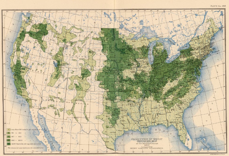
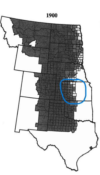
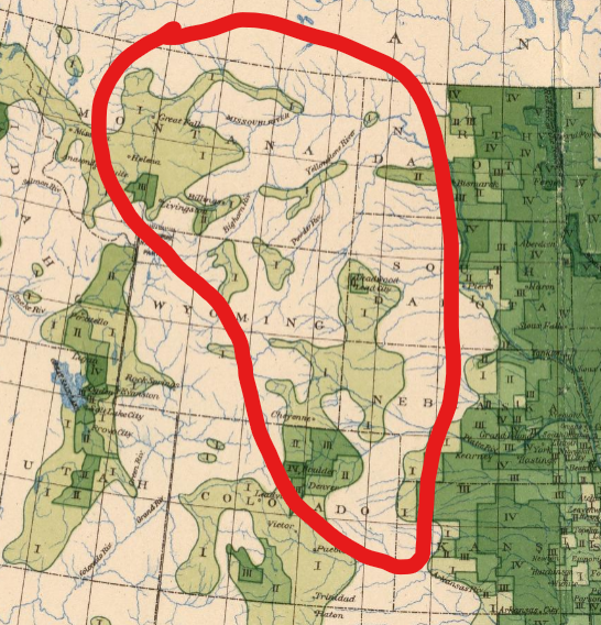
Cunfer uses several maps depicting the land use of counties across the Great Plains. His map of the percentages of unplowed grassland across the Great Plains in 1900 closely mirrors the map from the U.S. Census Office published in 1903. The highest wheat producing areas on the Great Plains in the Census Office map mirror the counties in Central Kansas, Eastern/Central Nebraska, and the eastern edges of the Dakotas where large swathes of land was plowed across most counties.
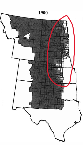
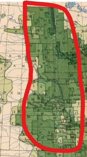
In his analysis, Cunfer focuses on Rooks County, Kansas. Cunfer discusses how by 1900, Euro-American farmers had plowed substantial portions of Rooks County Central Kansas as white settlement increased while settlers took advantage of a climate that enabled widespread grain cultivation.[1] This is apparent in both Cunfer’s and the U.S. Census Office’s maps. Cunfer’s map shows that somewhere between 20-50% of the land the counties of Central Kansas around the turn of the 20th century was plowed for grain cultivation with 50-80% left as pastureland.
The U.S. Census Office’s map depicting the same area just three years later makes a similar argument. It shows how in 1903, farmers in much of Central Kansas produced up to 3,200 bushels of wheat per square mile. With such high levels of productivity, the climate and soil must have been widely arable and conducive to wheat production, leading to more extensive plowing to cultivate more land.
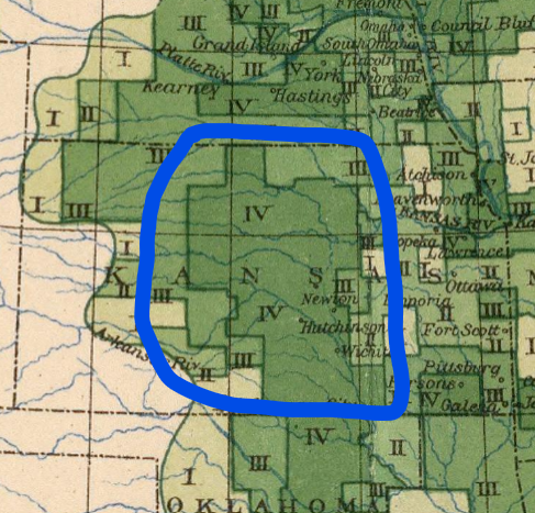
Cunfer points out how rainfall and the rarity of crop-destroying frosts in contrast to croplands further north on the prairie enabled such high agricultural productivity with extensive plowing in Central Kansas.[2]
The importance of environmental factors to grain cultivation on the American prairie is evident in Cunfer and the U.S. Census Bureau’s maps. Lands further west on the prairie were much drier than lands further east. This severely limited the ability of farmers to successfully cultivate crops, such as wheat, as lands further west were simply too dry. As a result, this land was largely left unplowed with the original prairie being used as pastureland for livestock.
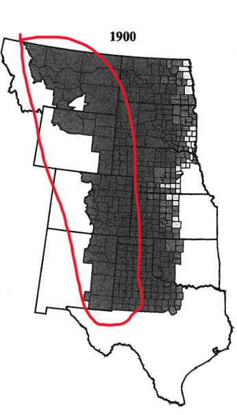
Both these maps reflect Cunfer’s argument that environmental factors largely determined agricultural cultivation and productivity in the Great Plains as drier areas produced lower crop yields and had more pastureland.
Whenever one maps anything there are always omissions and biases, either implicit or explicit, in the mapping product. The relatively small scale of both maps discussed above forces omissions of vital topography, homesteads, and Native American lands that all characterize the Great Plains and color the mapped area. In my final project, I will have to make omissions on the map I produce as one cannot depict every single thing in a mapped area within the limits of one or more maps. That herculean task is simply impossible. However, I must be attentive to and acknowledge the omissions and biases in the map of mining boom towns in the Colorado Rocky Mountains I will produce for my final project. I must acknowledge whether the omissions and biases in my maps are implicit or explicit on my part and how I can minimize them or appropriately acknowledge their presence and the limitations of mapping as a medium to convey information and propose arguments. I must remember that the map I will make for my final project is a proposal and argument and that as with any reasonable proposal or argument it must not be deceitful or misleading. Maps play a uniquely authoritative role in how people view the world as they claim to depict the world “as it really is.” As a result, I must constantly reanalyze the map I make for my final project from the perspective of a viewer who is seeing my map for the first time. I must ask myself if what I am proposing through my map would be untrue, deceitful, or easily misunderstood and misconstrued by viewers, providing them with a false or inappropriately biased perception of the Colorado Rockies and the people that lived there. Of particular relevance to my final project is the settlement of Native American lands in the Rocky Mountains by white Euro-Americans. Unlike the maps of the Great Plains discussed earlier in this post, I want to make sure that I find a way to at least acknowledge Native American inhabitants of the Rockies and their role in white settlement and mining in the Colorado Rocky Mountains. To me, it is unacceptably misleading to omit recognizing the active Native American historical presence in and around the Rocky Mountains, or else I may appear to present the unethical and false proposal in my map that prior to white settlement, land in the Colorado Rockies was “empty” and “unused” by humans.
Bibliography
[1] Geoff Cunfer, On The Great Plains: Agriculture and Environment, (College Station, TX: Texas A&M University Press , 2005), 27.
[2] Cunfer, On The Great Plains, 22, 29.
Map Citations In Order of Appearance
U.S. Census Office, Production of Wheat per Square Mile at the Twelfth Census, 1900, 1903, David Rumsey Map Collection, https://www.davidrumsey.com/luna/servlet/s/6kl0p8, accessed March 10, 2024.
Geoff Cunfer, Fig. 2.4 Percentage of Total County Area Not Plowed, 1880-1920, 2005, from On The Great Plains: Agriculture and Environment.
Nicely done! No notes.