Blog Post 2: William Smith

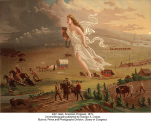
The UK, whilst appearing as a relatively unimpressive island adjacent to continental Europe, is somehow, throughout most of history, the luckiest empire in the world. In addition to colonizing over half the globe, when the Industrial Revolution rolled around, British people seemed to luck out once more, realizing their island is a giant mountain of coal.

Winchester, Simon. “A Land Awakening from Sleep.” The Map That Changed the World, Harper, 2001, p. 26.

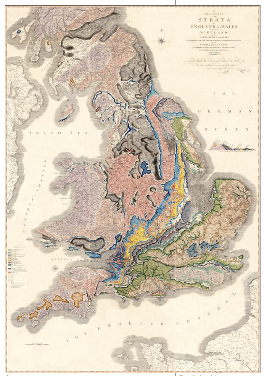
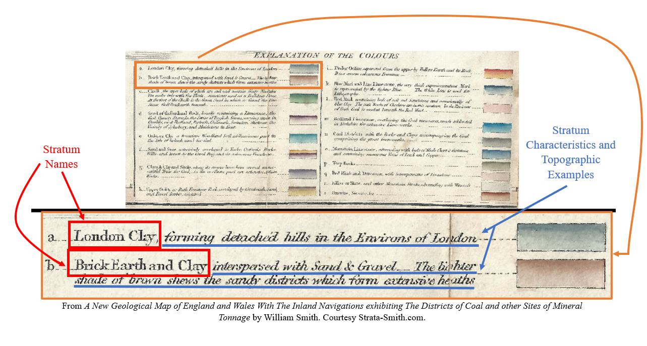
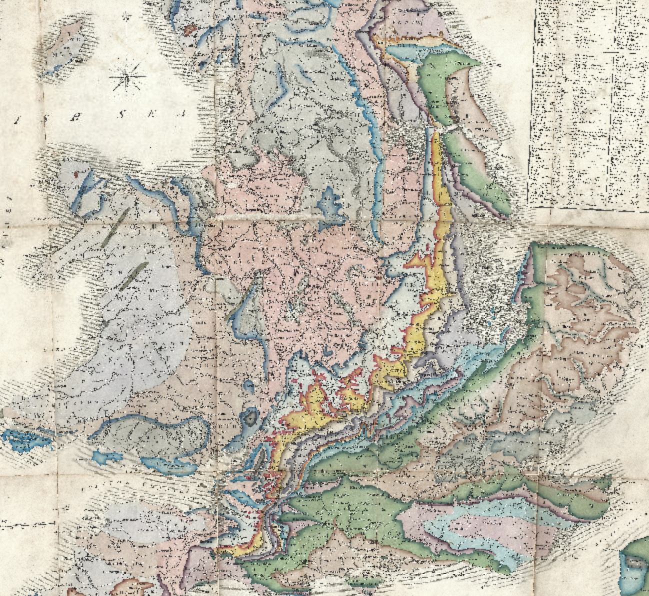
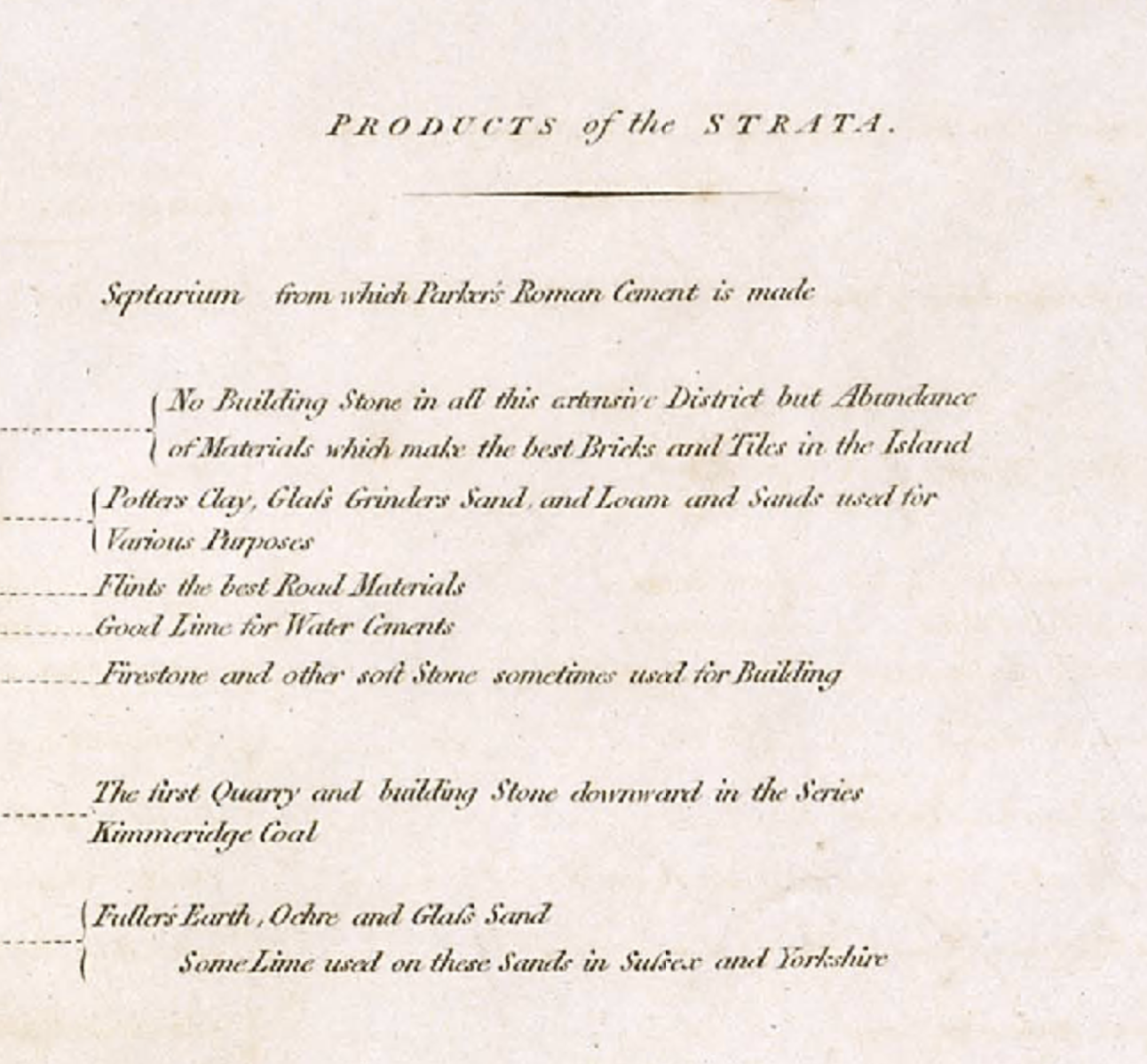
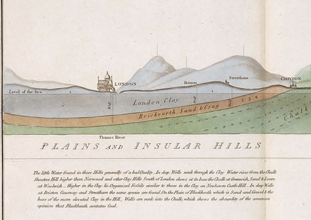
However, Smith was more interested in rock stratification and fossils than coal. He mapped the stratifications of rock and rock layers in great detail.

William Smith’s Geological Map of England and Wales, from http://www.strata-smith.com/map/.

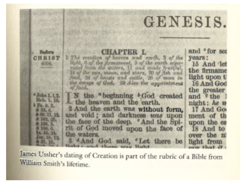
William Smith’s research worked in tandem with a relatively new and radical thought: the world existed long before the story of creation in the Bible’s Genesis.

From https://earthobservatory.nasa.gov/features/WilliamSmith.

The questioning of literal Biblical interpretations spurred not only Smith’s research, but industrialization itself. In order to use the coal found, they had to shun the idea that the world didn’t exist until humans came along. This also shifted the perspective that natural laws governed the physical world, rather than metaphysical/theologian laws/ideas governing the physical world. William Smith’s map came at a time when there was a shifting emphasis to scientific explanation and reason than focus on the spiritual.

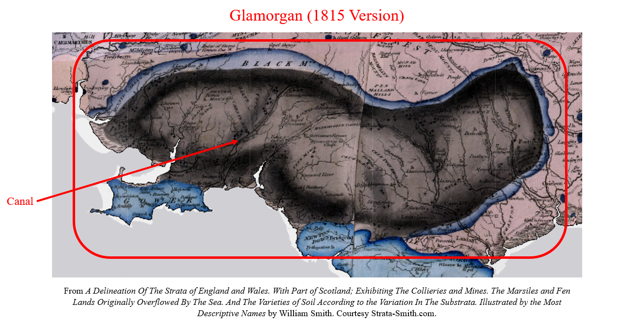
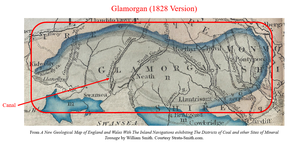
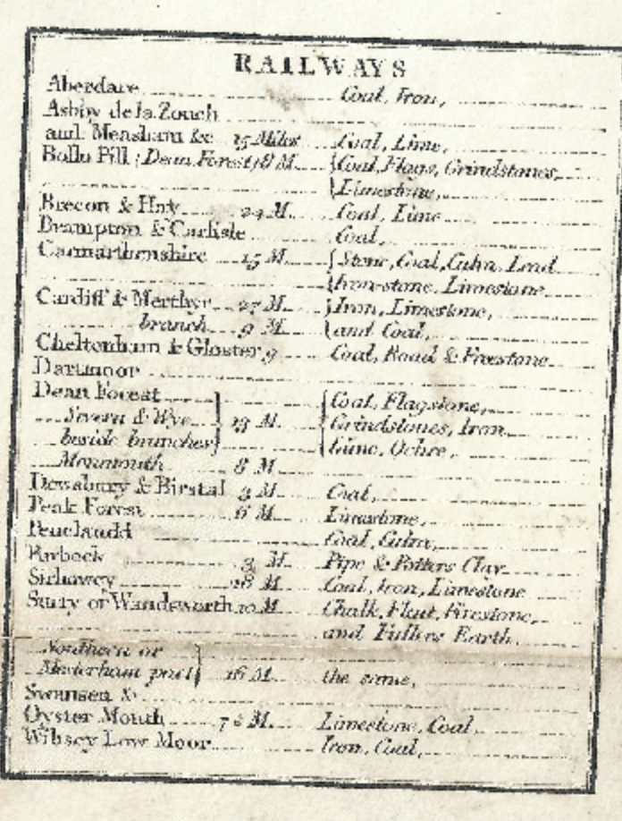
Although Smith’s map is crucial to understanding the world and what lies beneath, his map didn’t do well, as the British government seemed to trend more towards mapping coal mines and points of monetary value, rather than academic. Later, these maps were important for the transportation of coal through digging canals around England, but were relatively overlooked until then, with Smith rotting in a debtor’s prison and living in poverty upon his release. Later, when the Industrial Revolution kicked into full-steam, his maps were crucial in water management (aquifers identified), location of coal deposits, and canal construction.

Declan Dunham Weekly Blog Post 2: William Smith

William Smith’s geological map of England and its surrounding areas was one of the most detailed and descriptive geological maps of its time. William Smith’s Geological Map makes the argument of how England’s geological layers formed. In his map, Smith shares his idea of faunal succession. Because of William Smith’s discovery, scientists were able to better understand the history of Earth’s climate, geology, and biology.

William Smith describes fossil succession allowed Smith to place rock formations in chronological order. As a child of the Industrial Revolution, Smith grew up in a time when coal was an extremely important resource. Smith became a surveyor, requiring him to visit coal mines. While visiting, Smith noticed that rock layers occurred in a sequence of predictability.

Also during this time, The Enlightenment created advancements in science and philosophy. Many people asked questions related to the field of Natural Science. Specifically, the question of how our world came to be was at the forefront of Scientific Thinking. Many of these questions stemmed from religious aspects as well. It was a common belief that the world we lived in was created by God.

William Smith’s map allowed England to observe their land on a literal deeper level. These discoveries accurately ordered rock layers and allowed for England’s coal industry to expand. Not only did Smith’s discoveries provide an economic impact, but it was also a great scientific achievement. His discovery allowed us to understand the history of our Earth. We were able to learn that the history of Earth exceeds far past out initial idea. By discovering fossils and rock formations, we were able to accurately describe when different species existed. This discovery also allowed for scientists to better understand Earth’s climate history.

The discovery of William Smith originated as a way to expand the economy during the Industrial Revolution. However, the result of this discovery advanced science. The discovery of a predictable rock formation allowed scientist to better understand the history of Earth’s climate, biology, and geology.

Payton Mlakar Blog Post 2: William Smith’s Geologic Mapping

This map is a reference map proposing where subterranean geologic strata are located under England, Wales, and southern Scotland.

Usability was a clearly a key concern for William Smith in creating this map. The legend Smith included on the 1828 version of this map named each stratum, described the rocks present in each stratum, and assigned each stratum a color on the map. Most entries also included examples of topography made of each stratum.

With this detailed legend, a reader can easily identify specific strata on the map. This makes this map a highly effective reference map as a new reader can quickly and easily find information they are looking for anywhere on the map.

Between the 1815 and 1828 versions of his map, Smith dramatically improved the map’s usability by changing the color of several strata to make it easier for the reader to identify canals and other secondary features. One example is the change Smith made to the color of the stratum under Glamorgan in southern Wales. In the 1815 version of the map, Smith colored this stratum black with heavy shading around the edges. . .

. . . while in the 1828 version, Smith colored the same stratum light green, making canals and other landmarks easier to identify.

Nineteenth-century science played a role in Smith’s mapmaking by enabling him to accurately differentiate seemingly identical strata, making it possible for him to create this map. In his book The Map That Changed The World: William Smith and the Birth of Modern Geology, Simon Winchester describes how Smith discovered that seemingly identical strata could be differentiated by analyzing the subtle differences of the fossils they contained. [1] This gave Smith the proper tools and knowledge to effectively create his geologic map of Britain.

As described in an article chronicling William Smith and his work from NASA’s Earth Observatory, Smith “grew up when the Industrial Revolution focused England’s attention on [. . .] coal.” [2] This led Smith to work as a coal mine and canal surveyor, professions that allowed him to observe geologic strata across Britain and lent focus to his mapmaking. [2] Smith likely created his geologic maps to “accurately order rock layers and to help coal prospectors identify the best places to dig,” priorities that pushed him to make his maps easily usable for the coal industry. [2]

[1] Simon Winchester, The Map That Changed The World: William Smith and the Birth of Modern Geology, 1st ed. (New York: HarperCollins, 2001), 117-119.

[2] Michon Scott, “William Smith (1769-1839),” NASA Earth Observatory, NASA, May 8, 2008, https://earthobservatory.nasa.gov/features/WilliamSmith.

Map Citations (In order of appearance):

William Smith, A New Geological Map of England and Wales With The Inland Navigations exhibiting The Districts of Coal and other Sites of Mineral Tonnage, 1828, “William Smith’s Maps – Interactive,” http://www.strata-smith.com/map/, (accessed January 28, 2024).

William Smith, A Delineation Of The Strata of England and Wales. With Part of Scotland; Exhibiting The Collieries and Mines. The Marsiles and Fen Lands Originally Overflowed By The Sea. And The Varieties of Soil According to the Variation In The Substrata. Illustrated by the Most Descriptive Names, 1828, “William Smith’s Maps – Interactive,” http://www.strata-smith.com/map/, (accessed January 28, 2024).

Sam Ellerbeck Blog Post 2: William Smith

William Smith’s Geological Map of England and Wales is a very impressive depiction of the various layers of rock that span much of this island. From his upbringing during the onset of the Industrial Revolution in the late 18th and early 19th centuries, William Smith would have a decent understanding of the societal trends of the time [1]. With a rapidly increasing population and many renowned technological inventions, England and Wales in this time period were experiencing an overwhelming degree of socio-economic advancement [3].

William Smith’s Geological Map of England and Wales, showing the many rock type layers across the region. From Strata-Smith.com.

Longstanding biblical beliefs of the world’s creation by the divine had remained as the prevalent understanding of the earth and its nature. While the scientific understandings of the earth that we know today had not been available during this time, it was rather rather forbidden to question or challenge the biblically-driven perspective of the earth’s creation and the divine construction of human life. While the discovery of fossils gave way for some people question the accuracy of the biblical understanding, many geologists at the time conformed to the familiar grasp of the divine creation story, reluctant to contest society’s norm [3].

William Smith constructed much of his work based on his extensive analysis of fossils, discovering that some layers of rocks contained different fossils than other layers had. What is coined as “Faunal Succession,” Smith’s findings directly conflicted with the biblical perception of the world, as he came to the realization that the world isn’t necessarily as we had thought [3]. In his map, Smith focused primarily on depicting useful rock layers across the island, making sure to list the notable resources that can be found in these layers.

William Smith’s descriptions of specific products found in rock layers of England and Wales. From Strata-Smith.com.

William Smith’s map seems to have been made for industrial purposes in locating key resources for infrastructure, fuel, and architectural purposes. There is no mention of his fossil findings in each layer, or even the differences in fossils between the layers. Yet, he even goes so far as to include a list of railways.

Railways listed on William Smith’s Geological Map of England and Wales. From Strata-Smith.com.

Smith seems to have conformed to the long-held biblical understanding of the earth’s beginnings, as he too was reluctant to challenge these ideas – even with his fossil evidence. In making his map, Smith decided only to include items of commercial, economic, and industrial value. By omitting information about his theorized Faunal Succession, he sided with the theme of industrialization and avoided creating a social upheaval about our worldly understanding.

[1] Scott, Michon. 2008. William Smith (1769-1839). NASA Earth Observatory. https://earthobservatory.nasa.gov/features/WilliamSmith.
[2] William Smith’s Maps – Interactive. http://www.strata-smith.com/map/.
[3] Winchester, Simon. 2001. The Map that Changed the World. HarperCollins Publishers. ISBN 0-06-093180-9.

Gabe Murphy: Blog 2

A common theme arose while reading: coal, England’s fastest growing industry at the time. In the readings by Simon Winchester and Michon Scott, the upbringing of William Smith was greatly emphasized. In Scott’s account, Smith’s most important job was revealed:

Scott, Michon. “William Smith (1769-1839).” NASA, 8 May 2008, earthobservatory.nasa.gov/features/WilliamSmith. 

Smith traveled thousands of miles each year surveying the land for England industrialists in search for effective canal systems. Using this to his advantage, Smith “accumulated observations of strata and fossils in mines and canals” (Scott, 2008) in order to tell different rock deposits apart from one another. With the use of previous agricultural maps, Smith coded different layers by color: creating depth in 2-D. In 1815, Smith published A Delineation of the Strata of England… a part of this map is shown below:

MS County (Mosaic) + 1815 Geology Map, William Smith. “William Smith’s Maps – Interactive.” Smith Map, www.strata-smith.com/map/.

The contrasting colors Smith enacted in this map helped show differing rock formations, in a first of its kind large-scale geological map. Out of frame in the left corner is a map key defining the color and its correlating rock layer. But what exactly is the point? For that, Simon Winchester’s The Map that Changed the World is necessary.

Winchester, Simon. “A Land Awakening from Sleep.” The Map That Changed the World, Harper, 2001, p. 15. 

The idea that the world was only 5,772 years old began to be questioned in the late 18th century. But, there was little to no evidence to support such views. Those who held it were simply dismissed by those in charge and the general public continued to view the earth in light of Divine Creation. Smith, however, was a curious and undeterred individual who sought evidence to his claims. It was him in fact, with his publication of his map in 1828, who rifted the scientific and religious communities with evidence that the earth is much older than accounted for by the Bible.

Smith 1828 Map. “William Smith’s Maps – Interactive.” Smith Map, www.strata-smith.com/map/.

Depicted above is Smith’s map (1828), quite similar to his production in 1815. In fact, the same blaze-orange color and other blues seem to be used again to represent the different geological formations. This time though, Smith’s intent was not to map fossil fauna nor rock formations–it was for travel to reach/distribute coal. This map was much more detailed than before, marking towns, railways, canal systems, and many more geological features. Though first driven by motivation to prove the Earth was much older than Biblically noted, Smith’s later struggles with money turned him towards providing mapping for England’s biggest industry–coal.

Erin Buglewicz, Blog Post 1: Chase County, Kansas

At first glance, the Outline Map of Chase Co. Kansas, 1901 appears to be nothing more than a simple reference map. However, by giving it a closer look and considering historical context, this map creates a proposition about land and settlement in Chase County.

The 1862 Homestead Act allotted 160 acres of federal land to each adult or head of household, and this encouraged people to settle in the American West. This map depicts land still open for settlement and sale in 1901, and this is denoted by the “Warren Mortgage Company” stamp in the top right corner of the map. On the top left, there is a key (titled “Explanations”) that lists symbols for infrastructure, such as railroads, schools, and post offices, which would be important to people looking to settle there. The purpose of this is to show, as William Least Heat-Moon explains, that Kansas serves as an intersection within the United States, and it is not merely “barren, desolate, monotonous” (10).

However, it is important to note an obvious silence in this map: the presence of Native American land. In Heat-Moon’s book, PrairyErth, he quotes Robert W. Baughman to note that before land could be sold, the government first needed to “clear the way” by removing indigenous peoples from their lands.

This image has an empty alt attribute; its file name is Screen-Shot-2024-01-21-at-11.26.09-PM-1.png

As Heat-Moon depicts, many incoming settlers held the false notion that the land in the West was nearly empty. He effectively explains this idea by contrasting an overhead view, such as one seen from above in an airplane, that consists of twelve quadrants to a more detailed “deep map” of Chase County.

In doing so, Heat-Moon is trying to combat the myth of emptiness within Midwestern states like Kansas. Due to his heritage and background, he also acknowledges the tie that Native Americans have to the land by including a short story.

Different groups will interpret Heat-Moon’s depiction of Chase County in twelve quadrants in their own ways. In one aspect, it compares to the Outline Map of Chase Co. Kansas, 1901 because it depicts large white spaces, seemingly showing open plots of land. However, for Native Americans, these white grids showed that vastness of their land and their belief that the open land should not be subdued or sold.

References:

Heat-Moon, William Least. PrairyErth. London: Andre Deutsch. 1991.

“Outline Map of Chase Co., Kansas, 1901.,” Northwest Publishing. https://www.kansasmemory.org/item/209375/page/3.

Blog Post 1: Chase County Kansas

In two different maps of Chase County, Kansas, we can see that Kansas is more than just the landscape that is broken up into sections.
The first of the maps is the Outline Map of Chase Co. Kansas, 1901. This map was published by Northwest Publishing in Minneapolis, Minnesota.


This map is a reference map of the county laid out in a grid and provides a brief overview of various landscapes found within the county including rivers, churches, plot lines, wagon roads, railroads, schoolhouses, mines, and many more as outlined in the key in the upper right of the map.

The second of the maps is a Deep Map called PrairyErth, 1991, created by William Least Heat-Moon, a travel writer and historian.

PrairyErth is considered to be a Deep Map since it gathers and conveys its information by using other disciplines other than maps including, history and archaeology. Overall, the deep map is far less visual than the other map as it uses some maps but more so written metaphors and stories. PrairyErth breaks down Chase County, Kansas into regions and discusses them individually.

Looking at one map portrayed in PrairyErth, we can see a similar map style compared to the previous map. The map is also a reference map but includes similar a different things than the previous map. Both maps show the various towns, rivers, and railroads. The PrairyErth map shows a more modern-day look at Chase County. This can be inferred based on the inclusion of various highways and interstates such as the Kansas Turnpike also known as I-35.

Despite being nearly 90 years apart, the maps have similar arguments. I believe they both show what is deemed as important at the time of the map’s respective creations and omit what is deemed not as important. In both maps, there is an emphasis on transportation even though it has evolved from wagon roads to interstates. The more modern map omits items shown in the previous map such as the school houses and church. This could be because there are too many of them within the towns or the map maker does not deem them as important. These two maps together show the evolution of Chase County, Kansas, and allow the audience to see what was important at the time of the map’s creation and how interests have changed over time.

References:

Heat-Moon, William Least. PrairyErth. London: Andre Deutsch. 1991. 

“Outline Map of Chase Co., Kansas, 1901.,” Northwest Publishing. https://www.kansasmemory.org/item/209375/ Accessed on 1/22/2024

Leah R.K. – Post No.1 – Chase County Outline Map

John Gast, American Progress, 1872. Chromolithograph published by George A, Crofutt. Source: Prints and Photographs Division, Library of Congress.

Picturing U.S. History

The Chase County Outline Map was a proposal made by the Northwest Publishing Company in 1901 to any prospective buyer telling them that a bountiful amount of land was waiting for them to stake their ‘rightful’ claim on. This argument was heavily inspired by the present cultural ideal of ‘American Progress’ and the bringing of order to wild and unpredictable lands.

Historic Map Works

This cultural understanding of the world surrounding them which influenced them to make this argument at the time is featured heavily in this map above through the superimposed lines that divided up vast, unknown, landscapes into small, manageable plots of land many would soon come to lay their claim on. 

Historic Map Works

Not only does this map make simple something as complicated as nature, but it was also made to argue that this land was unquestionably the buyer’s own and that these prospective settlers had every right to come and live off of land they had never even seen at that point before. These efforts are made visible through silences such as the little effort made to disclose what groups occupied this land before the settlers. The only land markers being one’s previous settlers before them took efforts to construct such as houses, churches, wagons & railroads, &c. The red, yellow, and blue/green overlay indicates the names of subsections of Chase County such as Diamond Creek, Cottonwood Falls, and Toledo.  

The Northwest Publishing Company made this map with economic intent too though. There was more to be gained than just the subjugation of a foreign environment in it for them. Every number had a price tag and that money would be going to them, progress always comes with a cost, and this factor also distinctly determines what was and wasn’t included in the publication of this map.  As with most territorial maps from this era, the landscape of Chase County is oversimplified with no indication of level elevation, soil quality, or the names of the indigenous groups that could also be occupying the land. This is done so as not to give the prospective buyer any reason to think twice about buying and cultivating the land. Once it’s been purchased there is no way for that individual/family to get their money back, so any unfavorable conditions are ignored/swept off to the side.

Chase County Outline Map, Atlas: Chase County 1901, Kansas Historical Map (historicmapworks.com)

Picturing US History – John Gast, American Progress, 1872 (cuny.edu)

Madeline King, Blog Post 1: Chase County, Kansas – A Home

In two different maps, the sparsely populated Chase County, Kansas is shown to contain far more than just the divided landscape typically seen out a plane window in “flyover country.”

The first of the maps is the Outline Map of Chase Co. Kansas, 1901. This map was published by Northwest Publishing in Minneapolis, Minnesota.

Outline Map of Chase Co, KS. 1901.

This map takes a reference map. Laid out in a grid, the map illustrates a brief overview of Chase County and the various things found there, like rivers, plots of land (for farms), churches, post offices, and it identifies different settlements throughout the County (all illustrated with symbols identified in an explanatory key (circled). In order to encompass the range of land taken up by Chase County, the symbols appear on a small scale on the map.

The second of the maps is a Deep Map called PrairyErth, 1991, composed by William Least Heat-Moon, a travel writer and historian.

William Least Heat-Moon, PrairyErth, 1991

PrairyErth is described as a Deep Map, as it gathers and conveys its information in a much through cartography, history, archaeology, and other disciplines. It is far less visual than the previous map. It is mostly conveyed in written metaphors and stories. While the previous map encompassed all of Chase County at once, PrairyErth breaks down Chase County into regions and discusses them chapter by chapter.

Despite being so visually different, these two maps make one similar argument. Both maps make an argument that Chase County is a home. The explanatory key provided in the first map identifies places in Chase County like farms, wagon roads, houses, churches, and schools. These things are all more than just part of the landscape. They identify Chase County as a place that is lived and worked in. This sentiment is shared by Heat-Moon within his deep map. Heat Moon’s map contains quotes like “County lines do make separate kinds of community life, each a little different from the other,” identifying how a rural life develops community (Heat Moon, 7). The second map discusses how this population lives their lives with a singular high school, only a small amount of attorneys, and a need to travel to find other professions like doctors.

While Chase County is small in its population per area, both of these maps demonstrate that this “fly over country” and seemingly barren and empty prairie contains a home and way of life for people.

References:

Heat-Moon, William Least. PrairyErth. London: Andre Deutsch. 1991.

“Outline Map of Chase Co., Kansas, 1901.,” Northwest Publishing. https://www.kansasmemory.org/item/209375/ Accessed on 1/22/2024

Emily Gaddy Student Post 1: Mapping Chase County, Kansas

The map above is a map of Chase County, Kansas; more specifically, the map is a “plat map,” which serves to show potential surveyors how to divide property for development. The map showcases plots divided up into little, perfect squares and there’s a key that dictates where railroads lines should run and how the line should be divided up against the natural landscape.

While this map is seemingly innocent and seems simply as a way to divide land up to future prospectors, I can’t help but wonder about the erasure of the natives within the county. Within a capitalist society, everything is a commodity to be bought or sold, and land is sadly no exception to this rule. Natives, who lived on the land centuries before Europeans, were forced out and forcibly assimilated into European-based capitalism. In order to sell goods within capitalism, they have to first be given a name to make it easier for markets to understand the goods/products presented to them (or in this case land), and this map serves as a capitalistic naming tool for “Chase Country” and for the Warren Mortgage Company to more easily advertise to those looking to settle Kansas.

History is a subject that is impended and closely linked to rhetoric. Not to sound too Foucauldian, but names are a powerful tool. Before people moved to California, the Midwest was the “Frontier.” Places like Omaha were named so to showcase the “wildness” and the need to subjugate not just the Omaha peoples, but the land itself for Creighton telegraph lines and Union Pacific railroads- railroads to stitch the original 13 Colonies to new ones created under the guises of American Exceptionalism and Manifest Destiny. When something is named, not only does that make it marketable, but also controllable.

The erasure of names plays an important role within mapmaking. “Chase County” is a name from obvious European origin. The erasure shows the promise of the American West and the land waiting for white, eager explorers (glorified colonizers) and their families.

When I interned at the Durham Museum for the summer, I worked as a docent, doing tours for elementary school groups from all over Nebraska and Iowa. One program I had to do was the history of the pioneers of Nebraska and the settling of Omaha. I thought it was ironic that I was having to tell the history of Omaha while completely erasing the history of the people who the city was named after. After a while of following the lesson plans provided to me by the museum staff, I started to ignore them and make my own lesson plans to teach more about the people on the prairies and tell the kids that although the term “prairie” inspires images of tall, empty grasslands, there were people here centuries before white settlers. To make matters worse, I think it is rather dangerous when a city name like Omaha is commandeered into regular American vernacular, without thinking about the origins of the word. Other places include Apalachicola in Florida or Tallahassee or Sioux City; honestly, the list goes on and on. Cartography serves to not just showcase land, but to claim it, as well.

css.php