
The map named A Delineation of the Strata of England and Wales with a part of Scotland created by William Smith in the early nineteenth century was the first of it’s kind to map out by use of fossils to demonstrate topographic differences in the landscape of the United Kingdom. In the book The Map That Changed The World: William Smith and the Birth of Modern Geology, Simon Winchester was able to describe the intricacy of the map that led to many things building off of the information put together by Smith to create entirely new things that would have been difficult without the publication of the map. Although the education of the author was limited, the insights made by him are truly timeless and have led to several things that Smith would have never been able to imagine.
The changing attitudes of the time as mentioned in The Map That Changed The World: William Smith and the Birth of Modern Geology by Simon Winchester made it much easier for Smith to come out and publish his findings. People were starting to question things that had been unquestioned for centuries regarding religion which had stunted scientific findings. Especially those regarding the age of the earth and inhabitants before that of humans. The details that Smith honed in on were visually represented by using different colors to represent different fossils/geographic layers of the earth and used different hues to specify further on the layer being described as shown in Smith’s 1815 William Smith, Geological Map of Part of Great Britain.
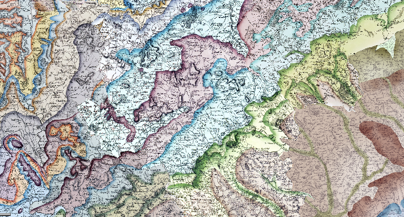
Which in comparison to William Smith, Geological Map of Part of Great Britain, 1828 is much less of a reference map than the 1828 version which shows towns in more detail along with roads and landmarks than the 1815 map. Additionally the colors are much more vibrant in William Smith, Geological Map of Part of Great Britain, 1828 with the colors being much more dramatized making it much easier to decipher which colors are the same and which are different from one another.
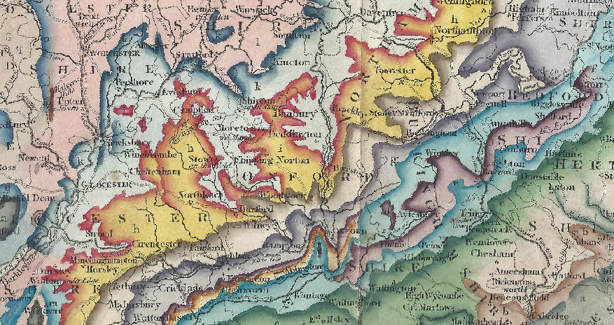
Both maps have similar legends for colors representing different rocks, however the legend for William Smith, Geological Map of Part of Great Britain, 1828 is much more detailed describing in less terms where each rock is common and if two are always seen together like sand and stone it is mentioned and visually represented.
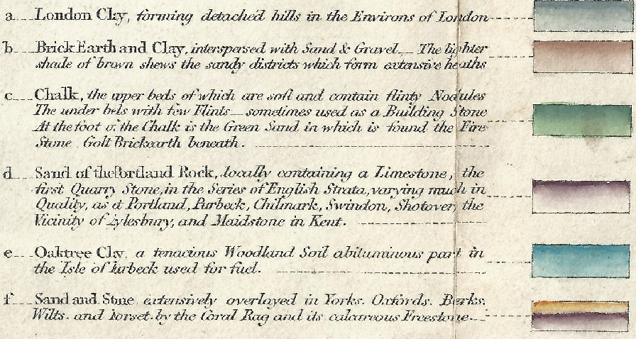
In an article written by Michon Scott for NASA Earth Laboratory about William Smith it details how Smith was able to start to tell different layers of rock apart by the different fossils found within the rock. With further observations however Smith was able to identify that seemingly two similar rocks may have several of the same fossil, however one to two species would vary between the two allowing Smith to differentiate between nearly identical pieces of rock and this discovery would eventually become known as Smith’s Principle of Faunal Succession and was visualized in the maps shown above.
Citations:
Scott, M. (2008, May 8). William Smith (1769-1839). NASA. https://earthobservatory.nasa.gov/features/WilliamSmith
Winchester, S. (2001). The map that changed the world: William Smith and the birth of modern geology (1st ed). HarperCollins.
These are some very nice descriptive details, which you frame in historical context using the readings. Good. I wouldn’t argue they were necessarily connected, though. Do the details you identify as changing between the 1815 and 1828 maps relate back to the material you began your blog with? About the age of the earth and whether Smith was aware of the implications of his own map? Doesn’t seem like it. Space is limited in these blogs – feel free to focus on ONE theme – your only restriction is that you need to bring the assigned sources to bear. Tighten up your analysis, in other words. Keep it up!