Blog Post #2

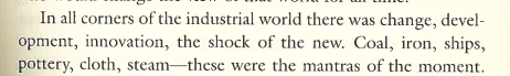
William Smith (1769-1839) was one of the most important early geologists who created a detailed geographical map of the United Kingdom.

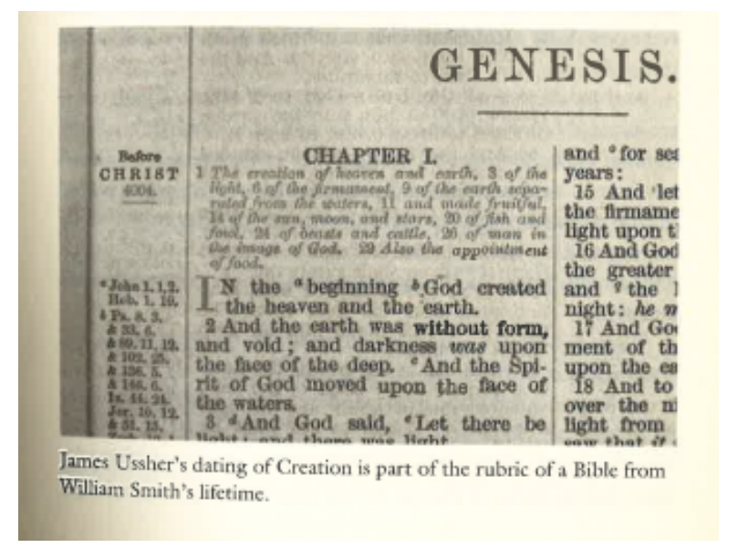
“The Map that Changed the World” is an excellent article that offers insight into the history of geology and its earliest theories for how the world was created. William Smith was born during the era know as the “enlightenment” a time when philosophical and scientific thought began to replace the “old” ways of thinking. However, when Smith became a geologist, some of the old theories remained in the field. Particularly, to the dating of the earth, which early guesses dated the age of the earth to over 4,000 years old.

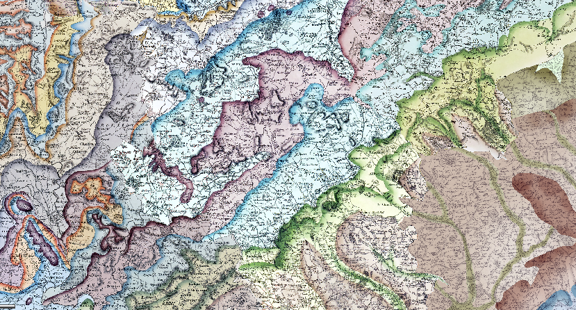
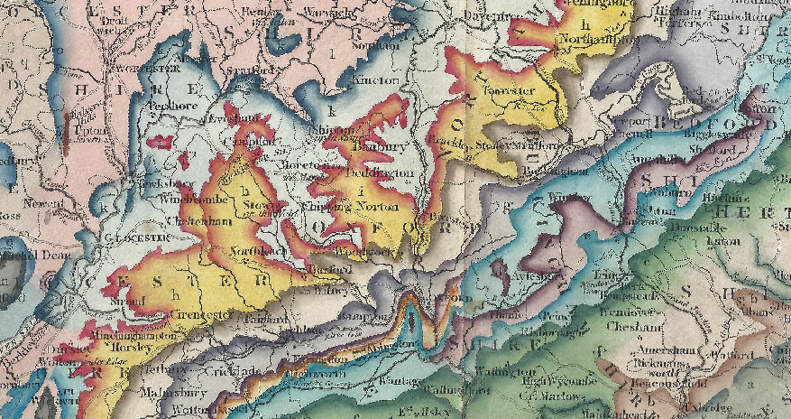
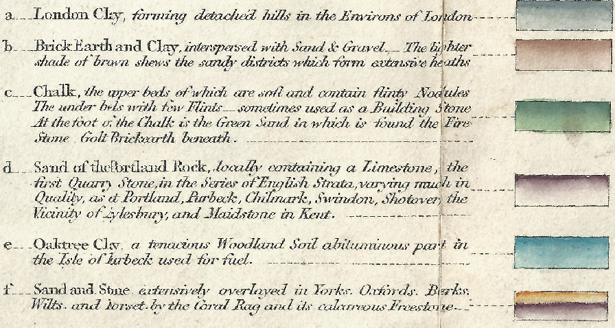
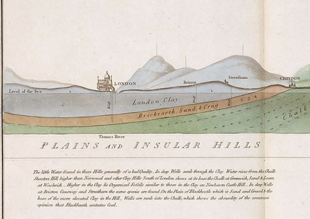
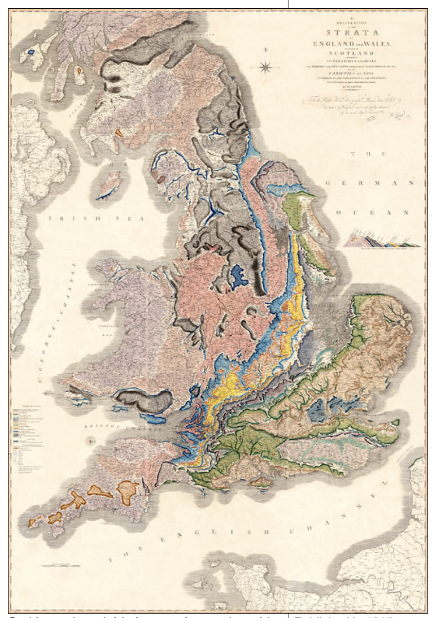
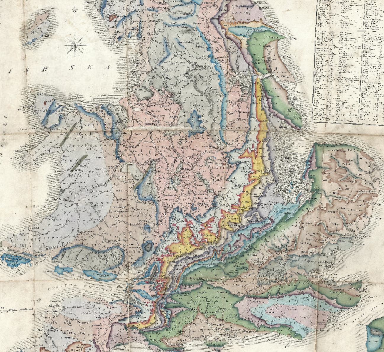
Smith’s map is incredibly detailed and helped to dispel the myth that humans and earth were created at the same time. The resource “William Smith-Interactive map” helped to visualize the detail Smith included in his map of the UK. In the interest of keeping my post to the assigned limit, I will focus my map discussion on the “Geological Section from London to Snowdon.”

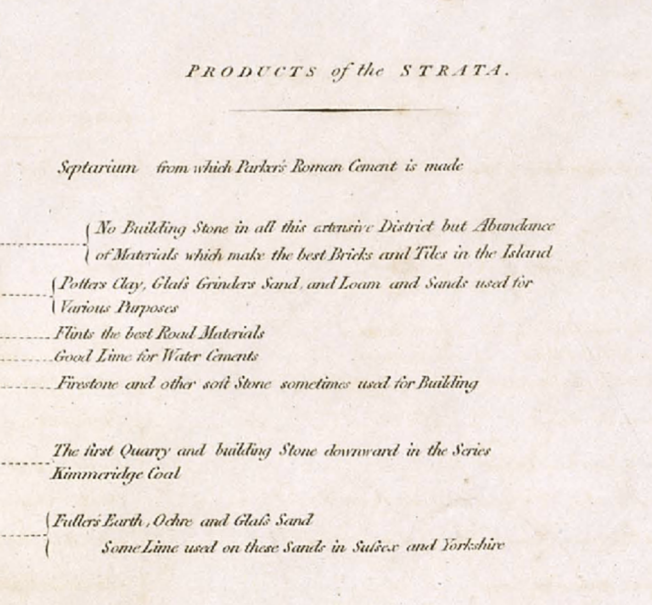
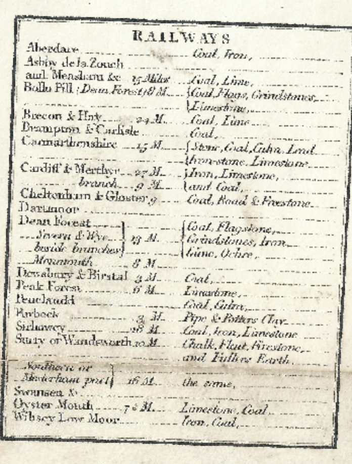
The geological map includes the correct height and altitudes of the hills, to the valleys found between the cities, and accurate measurements of the age of the geography found between London and Snowdon. Depicted in the map, the land around London is flat and open compared to the hilly countryside found outside of London. Which would explain why London has a lager population compared to Snowdon, which has a rugged and hilly countryside. interestingly the hills and geographic countryside near Snowdon is older compare to the formations found near London. They are also more developed which “could” indicate that the hills around Snowdon had more time to develop thus, their larger size compared to the hills found around London. I also like how the resource uses color to indicate the age and the different geographic features found on the map. It helps to visualize the age of each mountain, valley, and river found on the map and the geographic formations mentioned in the articles about William Smith.

https://earthobservatory.nasa.gov/features/WilliamSmith

Click to access snowdon_london.pdf

http://www.strata-smith.com/map/

Isabel Blackford Blog Post 2: William Smith’s Geological Map

The map named A Delineation of the Strata of England and Wales with a part of Scotland created by William Smith in the early nineteenth century was the first of it’s kind to map out by use of fossils to demonstrate topographic differences in the landscape of the United Kingdom. In the book The Map That Changed The World: William Smith and the Birth of Modern Geology, Simon Winchester was able to describe the intricacy of the map that led to many things building off of the information put together by Smith to create entirely new things that would have been difficult without the publication of the map. Although the education of the author was limited, the insights made by him are truly timeless and have led to several things that Smith would have never been able to imagine.

The changing attitudes of the time as mentioned in The Map That Changed The World: William Smith and the Birth of Modern Geology by Simon Winchester made it much easier for Smith to come out and publish his findings. People were starting to question things that had been unquestioned for centuries regarding religion which had stunted scientific findings. Especially those regarding the age of the earth and inhabitants before that of humans. The details that Smith honed in on were visually represented by using different colors to represent different fossils/geographic layers of the earth and used different hues to specify further on the layer being described as shown in Smith’s 1815 William Smith, Geological Map of Part of Great Britain.

Which in comparison to William Smith, Geological Map of Part of Great Britain, 1828 is much less of a reference map than the 1828 version which shows towns in more detail along with roads and landmarks than the 1815 map. Additionally the colors are much more vibrant in William Smith, Geological Map of Part of Great Britain, 1828 with the colors being much more dramatized making it much easier to decipher which colors are the same and which are different from one another.

Both maps have similar legends for colors representing different rocks, however the legend for William Smith, Geological Map of Part of Great Britain, 1828 is much more detailed describing in less terms where each rock is common and if two are always seen together like sand and stone it is mentioned and visually represented.

In an article written by Michon Scott for NASA Earth Laboratory about William Smith it details how Smith was able to start to tell different layers of rock apart by the different fossils found within the rock. With further observations however Smith was able to identify that seemingly two similar rocks may have several of the same fossil, however one to two species would vary between the two allowing Smith to differentiate between nearly identical pieces of rock and this discovery would eventually become known as Smith’s Principle of Faunal Succession and was visualized in the maps shown above.

Citations:

Scott, M. (2008, May 8). William Smith (1769-1839). NASA. https://earthobservatory.nasa.gov/features/WilliamSmith

Winchester, S. (2001). The map that changed the world: William Smith and the birth of modern geology (1st ed). HarperCollins.

Samuel Duncan, Blog Post 2: William Smith: Cartographical Pioneer

Simon Winchester, 2001, The Map That Changed The World: William Smith and the Birth of Modern Geology

The industrial revolution and its benefits have been fantastic for the cartographic race. With the rapid advancement of expansion and industry in Great Britain, it is no surprise that every aspect of society was altered. The cartography process saw a revolution in its sense through the booming market needs for coal and transportation. The deviation from the trodden path by cartographer William Smith created innovation in how maps were created and what maps measured.

  • – William Smith, Geological Map of England and Wales and Part of Scotland, 1815

Smith’s map was geologic. One of the purposes of the was to give details regarding possible transportation routes for the rapidly changing coal industry. His discoveries as a young surveyor led to his idea of “geological succession.” Smith’s process involved aspects of geology that were often disregarded. Many have theorized about the fossils found within stone. Smith looked further into the information that the fossils in the stone and dirt could provide. Both the Industrial Revolution and the Enlightenment contributed to Smith’s research. The benefits Smith was able to provide to the highest bidder allowed his discoveries to revolutionize cartography and geological study in Britain.

“Geographic Succession” is the process of dating fossils on Earth to put the stones in chronological order. The benefits of geographic succession allowed canal planners and railroad planners to place their routes on the strongest or densest ground to prevent catastrophes.

  • ©2007 analogueandy

The picture above is similar to the process Smith used to determine the ages and succession of stone.

Smith’s geological map carries an argument about the significance of considering more than what is visible right in front of us. The map vividly exhibits the diversity of geological features across England. Many people during the time of its creation were skeptical about its importance, failing to recognize the critical role it plays in planning essential infrastructure. Building rail tracks, for instance, requires much more thought than just laying them haphazardly. The map was created during a time when labor and workers were in high demand, and people were forced to take up professions in the industry. Respect for history and knowledge of the Earth’s formation became even more important.

Simon Winchester, The Map That Changed The World: William Smith and the Birth of Modern Geology, 1st ed. (New York: HarperCollins, 2001)

Michon Scott, “William Smith (1769-1839),” NASA Earth Observatory, NASA, May 8, 2008, https://earthobservatory.nasa.gov/features/WilliamSmith.

William Smith, A New Geological Map of England and Wales With The Inland Navigations exhibiting The Districts of Coal and other Sites of Mineral Tonnage, 1828, “William Smith’s Maps – Interactive,” http://www.strata-smith.com/map/

Blog Post 2: William Smith

The UK, whilst appearing as a relatively unimpressive island adjacent to continental Europe, is somehow, throughout most of history, the luckiest empire in the world. In addition to colonizing over half the globe, when the Industrial Revolution rolled around, British people seemed to luck out once more, realizing their island is a giant mountain of coal.

Winchester, Simon. “A Land Awakening from Sleep.” The Map That Changed the World, Harper, 2001, p. 26.

However, Smith was more interested in rock stratification and fossils than coal. He mapped the stratifications of rock and rock layers in great detail.

William Smith’s Geological Map of England and Wales, from http://www.strata-smith.com/map/.

William Smith’s research worked in tandem with a relatively new and radical thought: the world existed long before the story of creation in the Bible’s Genesis.

From https://earthobservatory.nasa.gov/features/WilliamSmith.

The questioning of literal Biblical interpretations spurred not only Smith’s research, but industrialization itself. In order to use the coal found, they had to shun the idea that the world didn’t exist until humans came along. This also shifted the perspective that natural laws governed the physical world, rather than metaphysical/theologian laws/ideas governing the physical world. William Smith’s map came at a time when there was a shifting emphasis to scientific explanation and reason than focus on the spiritual.

Although Smith’s map is crucial to understanding the world and what lies beneath, his map didn’t do well, as the British government seemed to trend more towards mapping coal mines and points of monetary value, rather than academic. Later, these maps were important for the transportation of coal through digging canals around England, but were relatively overlooked until then, with Smith rotting in a debtor’s prison and living in poverty upon his release. Later, when the Industrial Revolution kicked into full-steam, his maps were crucial in water management (aquifers identified), location of coal deposits, and canal construction.

Declan Dunham Weekly Blog Post 2: William Smith

William Smith’s geological map of England and its surrounding areas was one of the most detailed and descriptive geological maps of its time. William Smith’s Geological Map makes the argument of how England’s geological layers formed. In his map, Smith shares his idea of faunal succession. Because of William Smith’s discovery, scientists were able to better understand the history of Earth’s climate, geology, and biology.

William Smith describes fossil succession allowed Smith to place rock formations in chronological order. As a child of the Industrial Revolution, Smith grew up in a time when coal was an extremely important resource. Smith became a surveyor, requiring him to visit coal mines. While visiting, Smith noticed that rock layers occurred in a sequence of predictability.

Also during this time, The Enlightenment created advancements in science and philosophy. Many people asked questions related to the field of Natural Science. Specifically, the question of how our world came to be was at the forefront of Scientific Thinking. Many of these questions stemmed from religious aspects as well. It was a common belief that the world we lived in was created by God.

William Smith’s map allowed England to observe their land on a literal deeper level. These discoveries accurately ordered rock layers and allowed for England’s coal industry to expand. Not only did Smith’s discoveries provide an economic impact, but it was also a great scientific achievement. His discovery allowed us to understand the history of our Earth. We were able to learn that the history of Earth exceeds far past out initial idea. By discovering fossils and rock formations, we were able to accurately describe when different species existed. This discovery also allowed for scientists to better understand Earth’s climate history.

The discovery of William Smith originated as a way to expand the economy during the Industrial Revolution. However, the result of this discovery advanced science. The discovery of a predictable rock formation allowed scientist to better understand the history of Earth’s climate, biology, and geology.

Payton Mlakar Blog Post 2: William Smith’s Geologic Mapping

This map is a reference map proposing where subterranean geologic strata are located under England, Wales, and southern Scotland.

Usability was a clearly a key concern for William Smith in creating this map. The legend Smith included on the 1828 version of this map named each stratum, described the rocks present in each stratum, and assigned each stratum a color on the map. Most entries also included examples of topography made of each stratum.

With this detailed legend, a reader can easily identify specific strata on the map. This makes this map a highly effective reference map as a new reader can quickly and easily find information they are looking for anywhere on the map.

Between the 1815 and 1828 versions of his map, Smith dramatically improved the map’s usability by changing the color of several strata to make it easier for the reader to identify canals and other secondary features. One example is the change Smith made to the color of the stratum under Glamorgan in southern Wales. In the 1815 version of the map, Smith colored this stratum black with heavy shading around the edges. . .

. . . while in the 1828 version, Smith colored the same stratum light green, making canals and other landmarks easier to identify.

Nineteenth-century science played a role in Smith’s mapmaking by enabling him to accurately differentiate seemingly identical strata, making it possible for him to create this map. In his book The Map That Changed The World: William Smith and the Birth of Modern Geology, Simon Winchester describes how Smith discovered that seemingly identical strata could be differentiated by analyzing the subtle differences of the fossils they contained. [1] This gave Smith the proper tools and knowledge to effectively create his geologic map of Britain.

As described in an article chronicling William Smith and his work from NASA’s Earth Observatory, Smith “grew up when the Industrial Revolution focused England’s attention on [. . .] coal.” [2] This led Smith to work as a coal mine and canal surveyor, professions that allowed him to observe geologic strata across Britain and lent focus to his mapmaking. [2] Smith likely created his geologic maps to “accurately order rock layers and to help coal prospectors identify the best places to dig,” priorities that pushed him to make his maps easily usable for the coal industry. [2]

[1] Simon Winchester, The Map That Changed The World: William Smith and the Birth of Modern Geology, 1st ed. (New York: HarperCollins, 2001), 117-119.

[2] Michon Scott, “William Smith (1769-1839),” NASA Earth Observatory, NASA, May 8, 2008, https://earthobservatory.nasa.gov/features/WilliamSmith.

Map Citations (In order of appearance):

William Smith, A New Geological Map of England and Wales With The Inland Navigations exhibiting The Districts of Coal and other Sites of Mineral Tonnage, 1828, “William Smith’s Maps – Interactive,” http://www.strata-smith.com/map/, (accessed January 28, 2024).

William Smith, A Delineation Of The Strata of England and Wales. With Part of Scotland; Exhibiting The Collieries and Mines. The Marsiles and Fen Lands Originally Overflowed By The Sea. And The Varieties of Soil According to the Variation In The Substrata. Illustrated by the Most Descriptive Names, 1828, “William Smith’s Maps – Interactive,” http://www.strata-smith.com/map/, (accessed January 28, 2024).

Sam Ellerbeck Blog Post 2: William Smith

William Smith’s Geological Map of England and Wales is a very impressive depiction of the various layers of rock that span much of this island. From his upbringing during the onset of the Industrial Revolution in the late 18th and early 19th centuries, William Smith would have a decent understanding of the societal trends of the time [1]. With a rapidly increasing population and many renowned technological inventions, England and Wales in this time period were experiencing an overwhelming degree of socio-economic advancement [3].

William Smith’s Geological Map of England and Wales, showing the many rock type layers across the region. From Strata-Smith.com.

Longstanding biblical beliefs of the world’s creation by the divine had remained as the prevalent understanding of the earth and its nature. While the scientific understandings of the earth that we know today had not been available during this time, it was rather rather forbidden to question or challenge the biblically-driven perspective of the earth’s creation and the divine construction of human life. While the discovery of fossils gave way for some people question the accuracy of the biblical understanding, many geologists at the time conformed to the familiar grasp of the divine creation story, reluctant to contest society’s norm [3].

William Smith constructed much of his work based on his extensive analysis of fossils, discovering that some layers of rocks contained different fossils than other layers had. What is coined as “Faunal Succession,” Smith’s findings directly conflicted with the biblical perception of the world, as he came to the realization that the world isn’t necessarily as we had thought [3]. In his map, Smith focused primarily on depicting useful rock layers across the island, making sure to list the notable resources that can be found in these layers.

William Smith’s descriptions of specific products found in rock layers of England and Wales. From Strata-Smith.com.

William Smith’s map seems to have been made for industrial purposes in locating key resources for infrastructure, fuel, and architectural purposes. There is no mention of his fossil findings in each layer, or even the differences in fossils between the layers. Yet, he even goes so far as to include a list of railways.

Railways listed on William Smith’s Geological Map of England and Wales. From Strata-Smith.com.

Smith seems to have conformed to the long-held biblical understanding of the earth’s beginnings, as he too was reluctant to challenge these ideas – even with his fossil evidence. In making his map, Smith decided only to include items of commercial, economic, and industrial value. By omitting information about his theorized Faunal Succession, he sided with the theme of industrialization and avoided creating a social upheaval about our worldly understanding.

[1] Scott, Michon. 2008. William Smith (1769-1839). NASA Earth Observatory. https://earthobservatory.nasa.gov/features/WilliamSmith.
[2] William Smith’s Maps – Interactive. http://www.strata-smith.com/map/.
[3] Winchester, Simon. 2001. The Map that Changed the World. HarperCollins Publishers. ISBN 0-06-093180-9.

css.php