Emily Gaddy Student Post 1: Mapping Chase County, Kansas

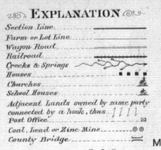
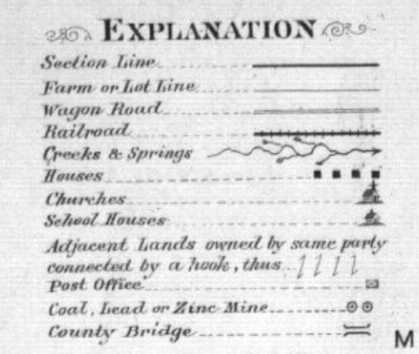
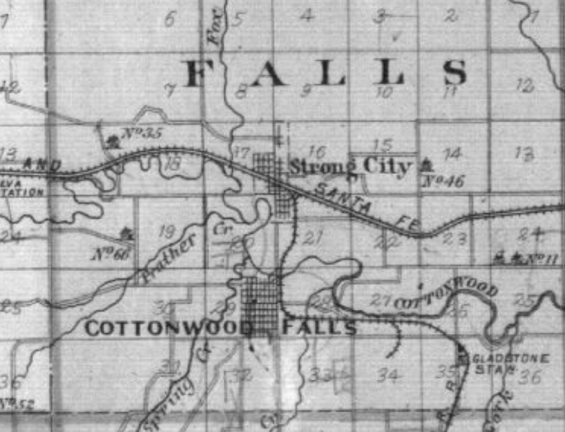
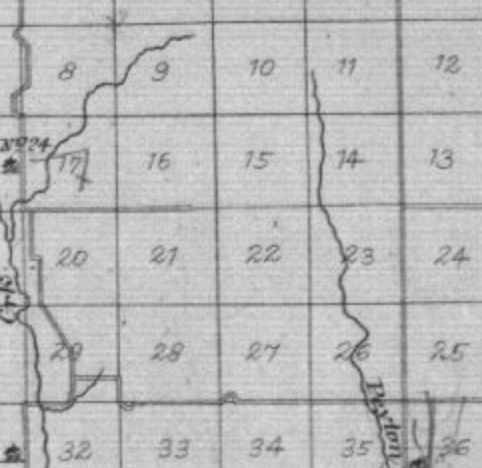
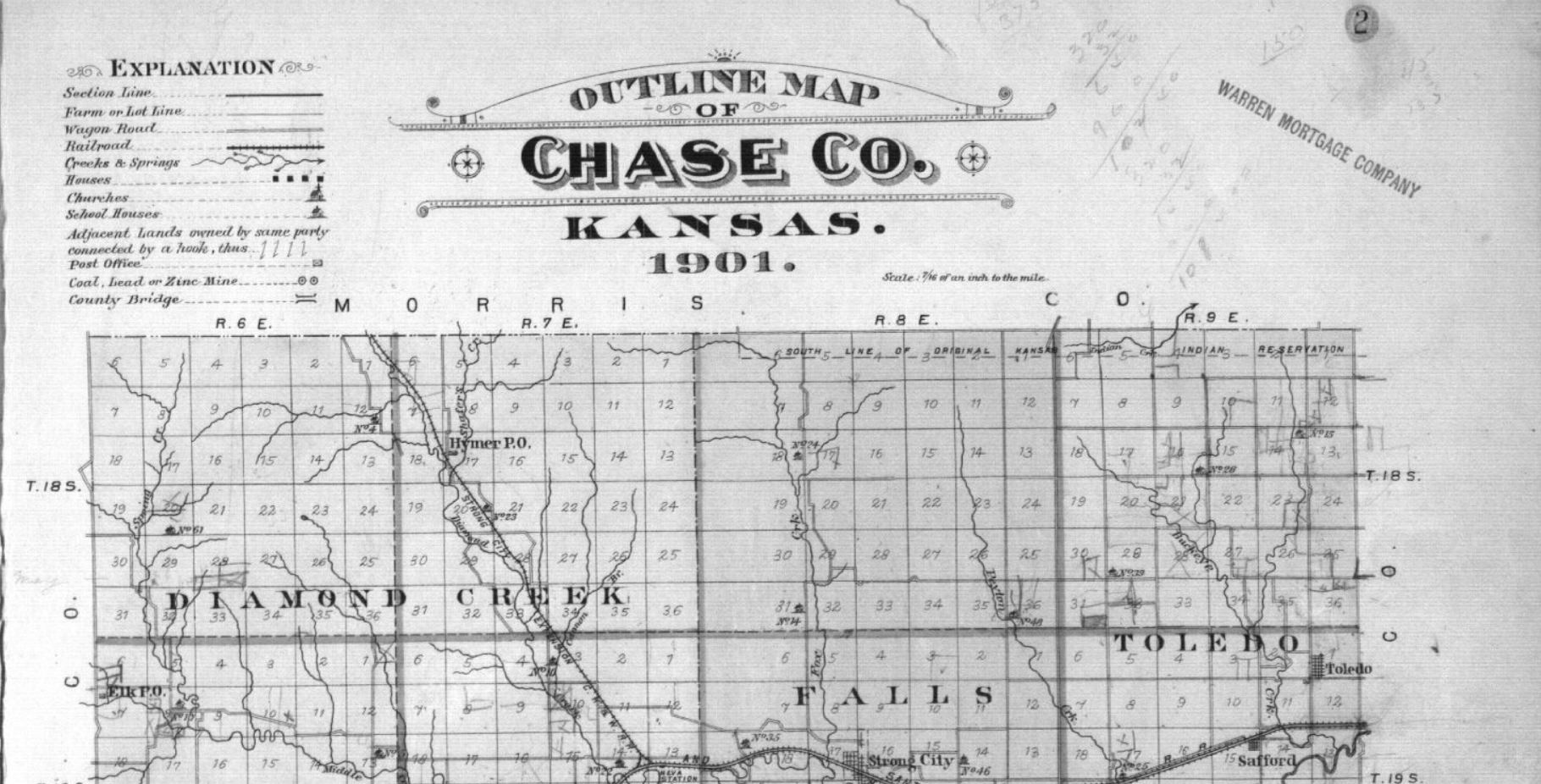
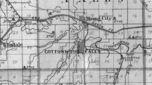
The map above is a map of Chase County, Kansas; more specifically, the map is a “plat map,” which serves to show potential surveyors how to divide property for development. The map showcases plots divided up into little, perfect squares and there’s a key that dictates where railroads lines should run and how the line should be divided up against the natural landscape.

While this map is seemingly innocent and seems simply as a way to divide land up to future prospectors, I can’t help but wonder about the erasure of the natives within the county. Within a capitalist society, everything is a commodity to be bought or sold, and land is sadly no exception to this rule. Natives, who lived on the land centuries before Europeans, were forced out and forcibly assimilated into European-based capitalism. In order to sell goods within capitalism, they have to first be given a name to make it easier for markets to understand the goods/products presented to them (or in this case land), and this map serves as a capitalistic naming tool for “Chase Country” and for the Warren Mortgage Company to more easily advertise to those looking to settle Kansas.

History is a subject that is impended and closely linked to rhetoric. Not to sound too Foucauldian, but names are a powerful tool. Before people moved to California, the Midwest was the “Frontier.” Places like Omaha were named so to showcase the “wildness” and the need to subjugate not just the Omaha peoples, but the land itself for Creighton telegraph lines and Union Pacific railroads- railroads to stitch the original 13 Colonies to new ones created under the guises of American Exceptionalism and Manifest Destiny. When something is named, not only does that make it marketable, but also controllable.

The erasure of names plays an important role within mapmaking. “Chase County” is a name from obvious European origin. The erasure shows the promise of the American West and the land waiting for white, eager explorers (glorified colonizers) and their families.

When I interned at the Durham Museum for the summer, I worked as a docent, doing tours for elementary school groups from all over Nebraska and Iowa. One program I had to do was the history of the pioneers of Nebraska and the settling of Omaha. I thought it was ironic that I was having to tell the history of Omaha while completely erasing the history of the people who the city was named after. After a while of following the lesson plans provided to me by the museum staff, I started to ignore them and make my own lesson plans to teach more about the people on the prairies and tell the kids that although the term “prairie” inspires images of tall, empty grasslands, there were people here centuries before white settlers. To make matters worse, I think it is rather dangerous when a city name like Omaha is commandeered into regular American vernacular, without thinking about the origins of the word. Other places include Apalachicola in Florida or Tallahassee or Sioux City; honestly, the list goes on and on. Cartography serves to not just showcase land, but to claim it, as well.

Marie Amelse Blog Post 1: Chase County

This plat map of Chase County, Kansas shows different areas of land mapped out in almost all identically sized plots of land, based on latitude and longitude. If you were to go one and view all the maps in this collection you would find how this cartography set up different towns, which are not all identical in land plots, but varying sizes based on who owns the land.

This plat map contains many silences in the environment that is being mapped for example the Flint Hills encompass Chase County and therefore more topography elements than just creeks and springs might be applicable to any type of mapping of this region. Instead, this map focuses more on man-made objects or concepts such as churches, lot lines, and mines, as shown on the symbols key, or “Explanations.”

Outline Map of Chase Co., Kansas. (Minneapolis: Northwest Publishing Co. 1901)

In the upper right-hand corner of this map, it is shown that it seems the “Warren Mortgagee Company” owns this map, they might not have been the creators of this map but did use it in some capacity. The silencing of the topography of this map would benefit a mortgage company in that prospective owners might not be aware of the type of plants and hills that occupy this land, as the Flint hills are relatively hard to cultivate. This information would surely deter a farmer from attempting to seek a mortgage company’s help.

William Least Heat-Moon wrote in PrairyErth, ” Maybe a grid was the answer: arbitrary quadrangles that have nothing inherently to do with the land,”, Heat-Moon is contemplating how we could possibly accurately represent the land, how we should represent the land. How could we communicate a location based solely on natural landmarks? Still, a grid feels so disconnected from the land. Later in PrairyErth, Heat-Moon includes a parable about how differently a place could be represented.

William Least Heat-Moon, PrairyErth (Boston: Houghton Mifflin, 2001), p. 16.

As opposed to a grid-type of the map, Heat-Moon shows a Native American interpretation of the land as a moving breathing thing, that was the sum of all it represented, not just a seemingly 2-dimension object. That it in no way could be put into simple boxes and passed off as an unmoving entity,

Declan Dunham Blog Post 1: Mapping Chase County, Kansas

The Outline Map of Chase Co., Kansas. 1901, and the PrairyErth map both convey the idea of population. Both maps attempt to increase the population of Chase Co. However, they attempt this in separate ways. 

The Outline Map of Chase Co. highlights the theme of population by identifying important markers that would provide potential settlers with necessary information. As you can see below, these include Churches, Schools, Post Offices, and much more. These locations provide useful information to potential settlers as many of them are families.  

Outline Map of Chase Co., Kansas. 1901. Kansas Memory, Northwest Publishing Co

However, three specific designations truly share the Map’s argument. These are the Lot Line, Wagon Road, and Railroad. The Lot Line shows all available plots of land in Chase County. Represented as a grid, it is evident that the map makers are highlighting the vast amount of land there is to settle on.  

Outline Map of Chase Co., Kansas. 1901. Kansas Memory, Northwest Publishing Co.

In the second map, PrairyErth, we see Chase County in a new way. We see this land as a group of people. In this map, we are shown quotes from those who live there. This map illustrates the beauty as well as what their culture, specifically farming, means to them.  

William Least Heat-Moon, PrairyErth (London: Andre Deutsch, 1991), 5

Overall, both of these maps promote Chase County, Kansas in different ways. The Outline Map of Chase Co., Kansas promotes Chase County by highlighting its economic capabilities. The author of this map was the Warren Mortgage Company. As a mortgage company, Warren produced this map specifically to generate wealth and increase population. This is why the elements of the map illustrate information that is beneficial only. 

In the second map, the promotion of Chase County stems from the people. This map is a much more personal and deeper map. It illustrates the beauty of Kansas and its culture while showcasing the struggle of what it means to live there. Contrary to the Warren Map, this map is not about profit. It is mapping the culture and history of Chase County.  

Gabe Murphy Blog Post 1: Chase County, KS

“Plat book, Chase County, Kansas – 2,” Kansas Memory, Northwest Publishing Co, 1901, https://www.kansasmemory.org/item/209375/page/3.

As I began to look over sources laid out for this week’s post, the map above seemed distinctively simplistic. If I were to lay down a map, and ask a class the easiest way to divide a map, this would be it. Taking an entire county (relatively square itself), and dividing it into 16 squares, broken up into 36 squares each, amounts to a total of 576 different plots of land–in the simplest manner. Easy, yet effective. But how come?

William Least Heat-Moon, PrairyErth (London: Andre Deutsch, 1991), 12. https://steppingintothemap.com/mappinghistory/wp-content/uploads/2018/01/P-William-Least-Heat-Moon-%E2%80%9CFrom-the-Commonplace-Book-Crossing%E2%80%9DPrairyErth-Houghton-Mifflin-2001.pdf.

In the midst of that, I stumbled across this passage. 60 years following the production of the first map pictured, Robert Baughman stated the purpose and effectiveness of the square plotting: survey and sale. Further taking into account the quick timeline noted by Baughman, the map’s purpose is concluded. First and foremost, it was to take the Indian land from underneath their feet, and in that be able to sell it to settlers looking to expand west. 

Included in the map, located in the top left corner, is the key: listed below.

“Plat book, Chase County, Kansas – 2,” Kansas Memory, Northwest Publishing Co, 1901, https://www.kansasmemory.org/item/209375/page/3.

Again, this is very simple. It noted farmland, roads (wagon and rail), water sources, and public buildings (churches, schoolhouses, and post offices). Given this, as well as the stamp of Warren Mortgage Company in the top right corner, it is easy to say this map was produced for selling plots within Chase County, KS. The audience was settlers; not natives of the land, but those of the US seeking expansion. This map would be horrific to use on the ground, though. It is a comprehensive view from above, with little real world application of the usual purpose of maps: guiding. There are little landmarks, and towns are nothing more than shaded areas hiding beneath other features. Instead of guiding, this map was created with the intent of selling land–which it appears to have been very successful at doing given the 1961 account of Robert Baughman in Heat-Moon’s PrairyErth. This is nothing more than a template, created with an intent for future development.

Riley Filipowicz Blog Post 1

I noticed a few things when I first took a look at this map. I notice it is an outline of Chase County which is located in central Kansas. It was created in 1901 and looks to be owned by the Warren Mortage Group. When I realized this map was either created or sponsored by a mortgage company a lot more really stood out to me. The key includes things like houses, post offices, and churches. A mortgage company is obviously trying to sell and promote areas in Chase County to new or potential buyers.

Westward expanision was easier than ever in 1901 and this map shows that. I think the mortgage group is trying to use the map to show what areas were heavily populated and what they had to offer. For example, Cottonwood falls looks to have tons of habited areas. That can be shown by looking at the map and noticing all the figures placed there. I also think the railroad going through this area further strengthens that this was a heavily populated spot in Chase County.

I think this map could further convey its message by possibly showing a prediction of what this area is going to look like. It could also show suggestions from the Warren Mortage Company on what areas they think would be good to buy property.

Sam Ellerbeck Blog Post 1 : Chase County, Kansas

The Outline Map of Chase Co., Kansas. 1901 appears to be a type of reference map, as main routes, railroads, streams, and locations are depicted. In one sense, these aspects of the map help to highlight important modes of travel in Chase County, offering some degree of interconnectedness between the locations shown. Other than this, however, the map maker does not include much detail in terms of landscape and topography. In fact, most to all of the land shown is void of any detail, with no depth or significant attributes present. This may have been used as a tactic to mask the true terrain of these areas.

Inconsistencies in detail, where transportation routes and main creeks are shown, but land is not well depicted. From Outline Map of Chase Co. Kansas. 1901. From KansasMemory.org.

This map had been produced by a mortgage company, which must have been in attempts to sell parcels of land to potential owners. It seems that this map was intended to entice farmers to settle here, given the depictions of significant modes of travel and resourceful water networks, both of which would be of value for agricultural purposes. Additionally, the square lots and their well-defined boundaries offer more reason to assume that this mortgage company had motives to sell land.

Well-defined plots of land in Outline Map of Chase Co. Kansas. 1901. From KansasMemory.org.

The map clearly creates the message that there is a plethora of land that is primed and ready for agricultural use. Untold in this map, however, is the true reality of the terrain. William Least Heat-Moon, in his book PrairyErth, highlights the endless prairies and vast hills that cover the grounds of Chase County. Heat-Moon’s extensive analysis is heavily contradictory to the intentions of the mortgage company, which may have tried to deceive farmers into purchasing land that is not well equipped for agriculture.

To better convey the reality of the landscape, the map maker should have added some sort of topographical element to offer some detail as to the land’s elevational changes. Additionally, borders that depict the boundaries of the vast prairie biomes would be insightful for potential land buyers. Unfortunately, however, there was clear intention to cover these features for profit, where the most pronounced plot line boundaries are inherently deceptive.

  • Heat-Moon, William L. 1991. PrairyErth. Houghton Mifflin Company. pp. 3-18.
  • Outline Map of Chase Co. Kansas. 1901. Plat Book. https://www.kansasmemory.org/item/209375/page/3

Evan Murphy Blog Post 1: Mapped Interpretations of Chase County, KS

The Outline Map of Chase Co. Kansas. 1901 was created to attempt to increase settlement in the county in the southeast quadrant of the state. The scan of the map that was provided even contains a stamp of the Warren Mortgage Company seen below. The map’s purpose is to enable and convince people to settle in Kansas in the early 20th century, and holds little mention of the difficulties that may arise while attempting to cultivate the land.

“Plat book, Chase County, Kansas – 2,” Kansas Memory, Northwest Publishing Co, 1901, https://www.kansasmemory.org/item/209375/page/3.

This massively incomplete mapping interpretation of the prairie misinformed those who purchased plots of land, setting them up for failure. Those who purchased land in the great planes were ill equipped to farm in the region due to a shortage of information on the soil types and farming techniques that should be used. The quick sale of these and other similar plots of land in conjunction with lackluster information on how to farm the land likely aided in the severity of the Dust Bowl within Kansas a few decades after the creation of the map.

Although this type of map is important for the sale of land it lacks the fundamental understanding of the climate and soil needed for farmers to succeed in the region. William Least Heat-Moon created a more helpful sort of scientific historical collage map consisting of information provided by many different sources. This information was made available at different times, some of which was available before the 1901 map was created, but much of it was not. Although this information was publicly available, it was not all in one place. For example, these two quotes on the first page of the written map would have allowed for a more complete understanding of the gumption needed to cultivate land in Kansas.

William Least Heat-Moon, PrairyErth (London: Andre Deutsch, 1991), 3. https://steppingintothemap.com/mappinghistory/wp-content/uploads/2018/01/P-William-Least-Heat-Moon-%E2%80%9CFrom-the-Commonplace-Book-Crossing%E2%80%9DPrairyErth-Houghton-Mifflin-2001.pdf.

Heat-Moon’s approach to mapping portrays a more complete view of the world through the combination of multiple sources. This provides an in-depth understanding of the climate and soil of southeastern Kansas that is difficult to convey to someone that has never been there. Overall, I feel as if Heat-Moon’s approach to mapping Chase County Kansas can be applied broadly to many parts of the great state. Had a map of this approach been available to potential settlers it certainly would have made them aware of the challenges they were going to undergo. This more complete and robust mapping attempt could have been helpful to settlers and reduced improper farming practices throughout the state of Kansas.

Isabel Blackford Blog Post 1: Mapping out Chase Co. Kansas

Both of the maps given seem to have been made for the purpose of settlers who have come to Kansas in the hopes of settling the area and farming the land. PrairyErth: (a deep map) by William Least Heat-Moon maps out the terrain with much more detail, telling others what to bring and describing the land how it appears as in real time. The Outline Map of Chase Co. Kansas. 1901 describes the layout of the land from a birds eye view in order to present where certain landmarks are in comparison to others with the purpose of showing quite literally an outline of Chase County Kansas circa 1901.

Since the Outline Map of Chase Co. Kansas. 1901 is an outline, it does not show Chase County in much detail outside of what is included in the legend of the map and even then there is no further descriptors outside of the symbol placed on the map.

However, Heat-Moon in his book describes how dense the grassland is, along with how barren the landscape is due to its lack of development. The harshness of the environment is described as much different than what the author or the intended audience has ever experienced, warning the settlers to be prepared. There is a town shown in the Outline Map of Chase Co. Kansas. 1901, Cottonwood Falls, which is probably the part of the map with the most detail due to the fact the author was most likely trying to draw people to Chase County to buy the empty lots of land there and make it seem like a less daunting task to develop.

The Outline Map of Chase Co. Kansas. 1901 acts as a visual aid for the layout of Chase County, Kansas in the early twentieth century showing where landmarks are with a legend, Heat-Moon’s book provides the details of what it was like to be actually there and how the environment was alike and different from what the author/audience knew. The Outline Map of Chase Co. Kansas. 1901 is clearly a reference map, showing the geographic area of Chase County, Kansas along with labeling railroad lines, lot lines, creeks, churches, and wagon roads. The book by Heat-Moon gives more of a background for the territory that makes up Chase County, Kansas in much more detail to its audience providing a description that is able to create more of a visualization of the area than that of the Outline Map of Chase Co. Kansas. 1901, a reference map.

Wyatt Greco Blog Post 1: Chase County, KS, as a Grid Map

Northwest Publishing Co.’s 1901 Plat Book of Chase County, Kansas, includes an outline map of the entire county. As evidenced by this map’s key (pictured below), human creations are prioritized over natural features.

Outline Map of Chase Co., Kansas. 1901. Northwest Publishing Co., Minneapolis. Retrieved from Kansas Memory.

Structures such as roads, houses, and churches are all identified with labels on the map. Only one category of natural features, labeled as “Creeks & Springs,” are included. Given that water is essential to settlement and agriculture, this inclusion fits with the generally human-focused purpose of the map. However, a view of the entire map reveals a more specific proposition.

Outline Map of Chase Co., Kansas. 1901. Northwest Publishing Co., Minneapolis. Retrieved from Kansas Memory.

The above map is dominated not by buildings or roads, which would be easily visible to those actually standing on the ground in Chase County. Rather, the most prominent characteristic of this map is the grid lines. This grid denotes the surveying of Chase County, which divided the area into sections and property lots. Given their mostly equal size and straight borders, one can infer that mathematics (not, say, topography or soil fertility) primarily informed the division of the land. Though the grid system is purely the creation of the human mind, the map nonetheless proposes that these lot and farm distinctions exist where they do. Unlike buildings, mountains, roads, or rivers, property only really exists on paper. And yet, through mapping, gridded property lots become a reality which binds society and individuals.

In his book PrairyErth, William Least Heat Moon contemplates the grid system as a framework for his literary “deep map” of Chase County:

William Least Heat Moon, PrairyErth (Boston: Houghton Mifflin, 2001), p. 15.

Heat Moon points out that the coordinate system is detached from land and history. While this detachment could allow broad room for Heat Moon to structure his exploration, it also alludes to an important reminder about mapping. Maps need not be strictly beholden to physical subjects—whether they be created by humans or nature. Instead, maps can impose ideas or legal conventions onto physical space. In the words of Heat Moon, maps like the one explored in this post have “allowed the wildness to be subdued.” Much is left out of the 1901 Outline Map of Chase County, and this is deliberate. The purpose of the map is to portray how the land has been organized and divided to facilitate ownership, not to recreate or represent the natural, or even certain aspects of the human, world.

Andrew Merfeld 1/22 – Weekly Blog Post

The map given to us of Chase Co. Kansas looks to me like it is an outline of Chase County in the southeast quadrant of the State of Kansas. I have circled my assumption in red in the picture below.

Just by looking at the title of the map, you can tell that William East had a very broad idea of the land he is depicting. It is to my understanding that East was trying to show the different resources that are available in certain areas of the county. If you take a look at the key, you can see that he is only depicting railroads, sources of water, houses, churches, houses, and the post office.

Its to my understanding that East is trying to show people who are unfamiliar with the area, certain things that are in the country in relation to lots or land they may be looking to purchase. Going off of that, you can tell this is a depiction of land that is either owned, or trying to be sold, by the lot number that is in each box.

Here you can see random lots in which I circled which may be either up for sale or already owned.

Tying this all together, I think this is an outline of the Chase Co. in Kansas that is supposed to be used by people who are looking to buy land, so that they can see the resources that are close, or far, from wherever they may be looking to buy.

I think that something East left out that could be the lack of elevation depicted. In order for potential homeowners to truly know what they are getting into just by looking at a map, I would think it would be beneficial to know how elevated the land may be, in order to prevent flooding, etc. I also believe the map is a snapshot in time. I don’t see any elements that suggest there has been change in time according to the key.

In my opinion, I think in order for the map to fully convey its message, it would need some sort of elevation element, so homeowners can know what to expect when looking at a certain lot.

css.php