
Emma Reed Deep Map
Blog Post 1: Chase County Kansas

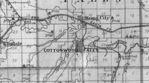
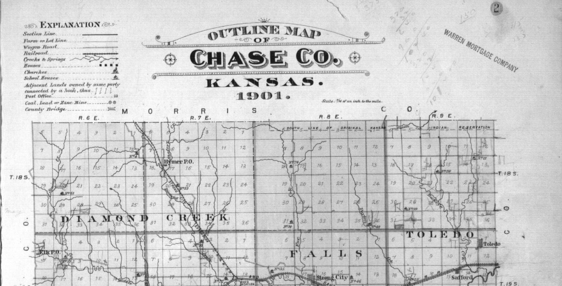
In Outline Map of Chase Co. Kansas, 1901 published by the Northwest Publishing Company the audience can see a very clear depiction of the settlements, as well as the surrounding nature such as: creeks, rivers, and various open and undeveloped spaces. It is very obvious that this map is showing all of the untouched land in the western rural states. Ironically, the Homestead Act of 1862 was enacted shortly before this map was published. The Homestead Act gave the heads of the household 160 acres of land in rural western states as an incentive for people to expand west.
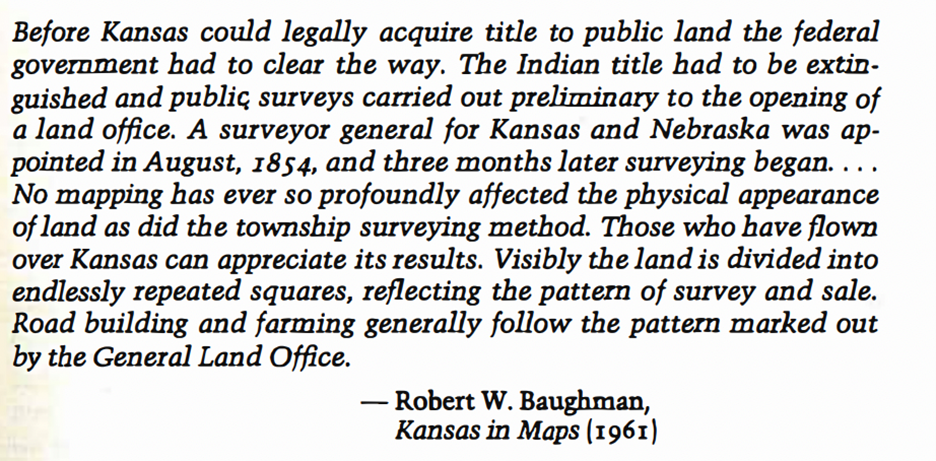
This also plays into the main silencer in this map is the space that was occupied by Native Americans. William Least Heat-Moon quoted Robert Baughman in PraryErth as ‘the government needing to come in and “clear the way”‘ before people were officially allowed to move westerly. Heat-Moon allures to the fact that many people were not even aware of the Native Americans occupying this land, because they was no way from them to obtain that knowledge.

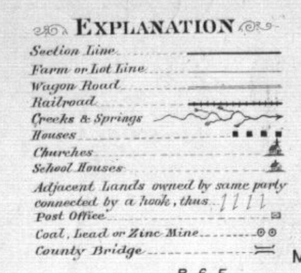
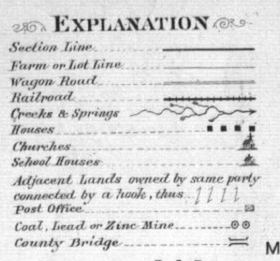
This map does however do a nice job of detailing where the railroads, churches, schools, rivers, and more are located. The map also shows the careful placement of county lines and architecture being used as the separating factor for towns rather than railroads and rivers as seen by Heat-Moon in PraryErth. This map overall offers a deep and thorough analysis of Chase County for its time.

The Warren Mortgage Company that authored this map would have wanted a more detailed map to entice westward expansion and increase the economy by doing so. They were careful enough to include street names in portions of their map, in what I am assuming is because they wanted to show that this area was already developed and could not be owned, but if people were to expand then they would have the chance at their very own land. Overall this map was very well thought out for its purpose.
Blog 1: Chase County: Empty Lie
In Outline Map of Chase Co. Kansas, 1901, proposed by the Northwest Publishing Company, land appears as if it is easily divided and controlled. The map itself gives the audience the idea that the rural western states are under the domain of man. The precise tooling required used to separate the lines down into individual sections give the viewer the idea of an urban environment in a way. The Homestead Act of 1862 gave heads of households 160 acres of land out in the rural states out west. The act itself was meant to help incentivize people to move west and use the millions of acres available.
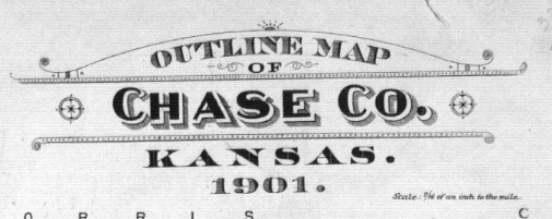
The map appears as a simple yet detailed display of the county lines, infrastructure, and nearly every aspect of the mapped area down to the smallest creek crossing. But the map itself can be seen as a primary source from the era to depict how confidently geographers and cartographers compartmentalized and dedicated land that was available.
Land and borders were no longer determined by creeks, railroads, or even topography. This is seen in PraryErth by William Least Heat-Moon.
Land had become a commodity and a weapon during the time of the creation of the map of Chase County. It was commodified in the way that appeared simple and monotonous enough for Americans to relocate themselves in rural areas like Chase County. The Homestead Act was also utilized as a weapon against the native population in the area.
The native population surrounding rural communities like Chase County did not view land ownership, nor land as something to control or take dominion over. As seen in multiple sources, including A Topographic Map of Words Parables Of Cartography In William Least Heat-Moon’s PrairyErth by O. Alan Weltzien. Weltzien’s writings regard parts of Heat-Moon’s book regarding the differences in native ideas of land versus colonial America’s policies. Both pieces of writing can be seen to support the idea that policies like the Homestead act of 1862 was a method to remove natives by encroachment.
The Map of Chase County is a display of America’s ideas of domination over the land. The reasoning behind the “crossings” on the map are used to incentivize settlers, reduce land to a commodity, and weaponize the land to defeat an enemy with different beliefs.
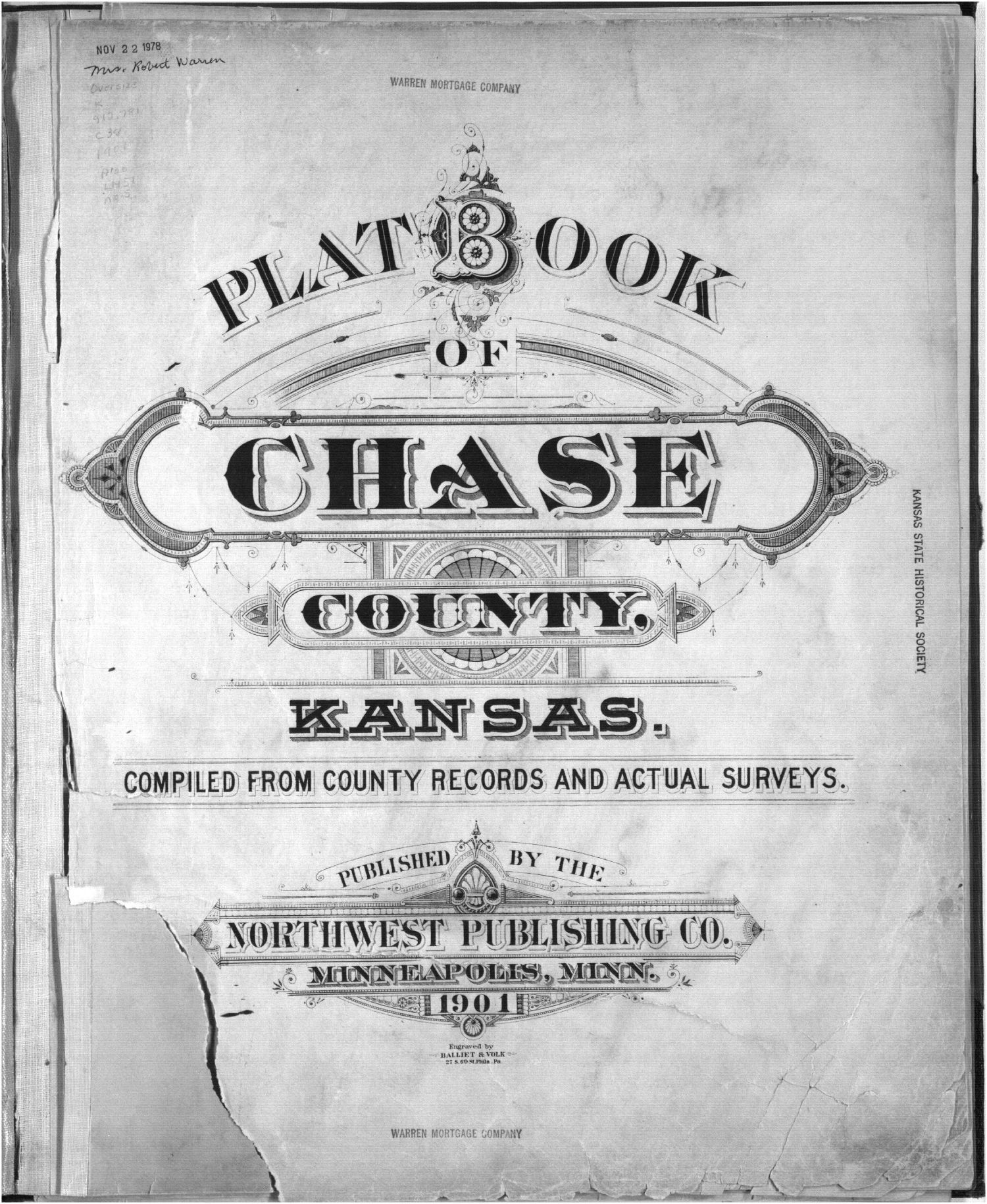
Plat book, Chase County, Kansas – 2
A Topographic Map of Words Parables Of Cartography In William Least Heat-Moon’s PrairyErth: Alan Weltzien
PrairyErth (A deep map): William Least Heat-Moon
Blog Post #1: Chase County Kansas
In 1862, the Homestead Act was passed which allowed a certain amount of land to be owned by settlers to cultivate and farm. This pushed an increasing amount of settlers to move out west and establish their claim in the vast lands of the west and Midwestern United States. One of the counties where immigrants and settlers flocked to was Chase County Kansas.
The 1901 map of Chase County Kansas is typical for a map of a “frontier” town. Its a simple design that contains landmarks and other sites that would be important to settlers. Some of these landmarks are churches, school houses, county stores, and the path the railroad would take. Perhaps the most interesting feature on the map is the appearance of valuable farm land on the map and land that is already owned.
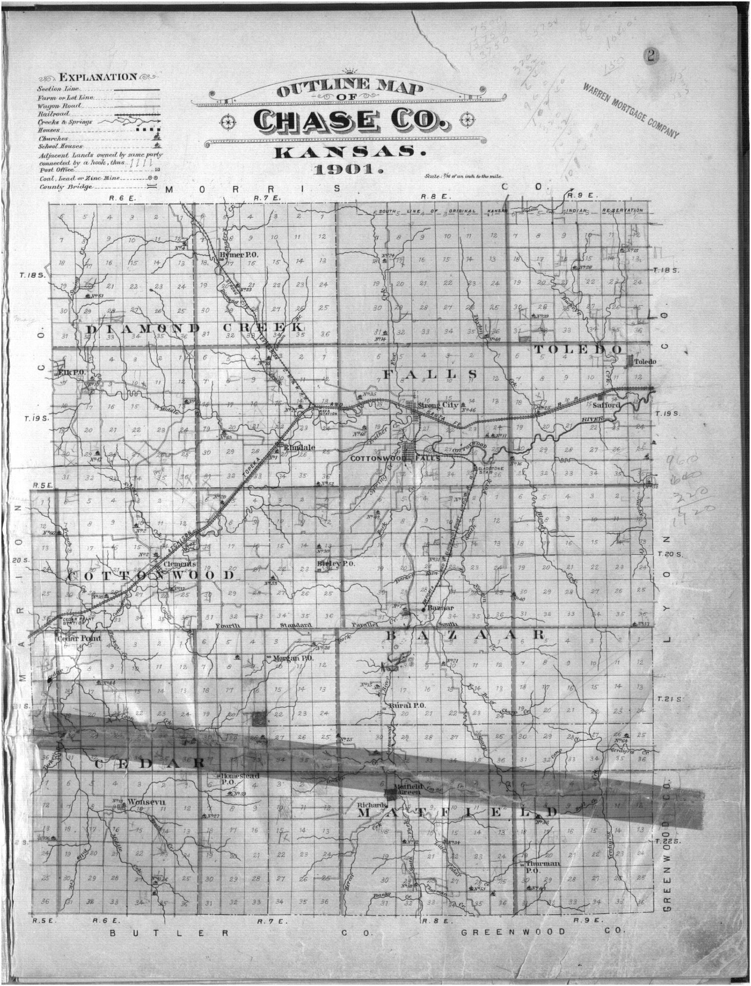
The size of the available farm land is what initially drew settlers to the plains of Kansas/”flint hills.” Before the flint hills was found to be too rocky and the soil was found to contain too much flint. The area of Chase County was an attractive place to settle for new immigrants coming into the Kansas territory. This is in large part thanks to the railroad which brought business, settlers, and supplies to the county and community. However, the designation of owned property and property lines would “possibly” give a way for the county to determine the annual census. And to decrease the chance for property disputes to occur.
Which brings me to my conclusion on the “Chase County Map.” I believe that the map was made to serve as a guide to new settlers/visitors. One, the map contains landmarks and where they are located within Chase County. Giving new people a reference of what is located in Chase county and the path that the railroad takes through town. Also, the markings of available farmland in Chase County shows new settlers what land is available for cultivation. And what land can legally be purchased by the new settlers moving into Chase County. The designation of purchased/owned land prevents new settlers from clamming land that is already owned. Thus, preventing property disputes or lawsuits taking place for control of the land.
Emma Reed, Blog Post 1: Chase County, Kansas
The Outline Map of Chase Co. Kansas, 1901 looks as though it is a relatively simple map. However, upon further investigation, it becomes apparent that it intends to increase the movement of people and settlement within the region. Since the author of this map was Warren Mortgage Company, one can imply that the intended purpose of the map was to increase settlement, and therefore increase the economic state of the County.
This map depicts important information for prospective settlers such as schools, churches, post offices, and more. Going into more detail, one gets to the heart of the map argument as seen through its depiction of railroads, wagon roads, and lot lines. These lines do not just show means of travel throughout the area, but also showcase the areas of land that settlers could live on.
PrairyErth shows Chase County from a different perspective that can help create a more holistic understanding of the region and its settlers. The map looks at Chase County more from the angle of culture and the traditions that the settlers have as it shows quotes from those who live there. Through this, viewers can come to learn about their way of life and particularly how important farming is in their community.
Finally, these maps showcase the different aspects of Chase County but they both have the end goal of increasing settlement. The Outline Map of Chase Co. Kansas, 1901 looks at the region through the lens of economics while the PrairyErth map looks at the region from the approach of culture. Both provide needed backgrounds on the County for incoming settlers but have different approaches as to achieving that.
Chase County, Kansas Blog Post 1 Michael Lau
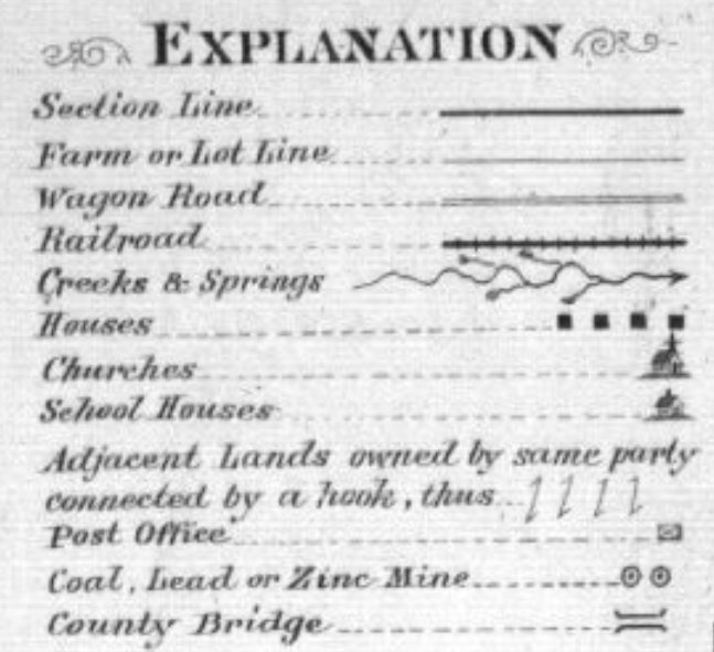
The Plat Book of Chase County, Kansas, is a property map from 1901. Published by the Warren Mortgage company, the map features no topography or latitude or longitude lines which would indicate a travel map. However, in its legend, it does indicate the various modes and methods of travel that are placed throughout Chase County. The county, however, is split into townships, with each of them being a parceled out more into differing estates. All of them numbered. Towns and cities are hatch marks, with the map taking particular focus on the transportation and the public services in each area. The Legend hinting to their priorities as schools and churches are given a symbol.
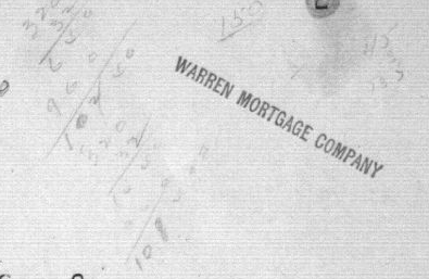
The map has several hand drawn additions and math surrounding it. It appears that the map was for investors in the region, or new homesteaders, to mortgage their land from the Warren Mortgage Company.
At the same time, this audience would either be locals or completely blind to the kind of land that they were buying, as besides whether there was a river on the property, there is no topological or ecological data present on the map. The people buying this land were thus not farmers or those who cared about the land other than for its location. O. Allen Weltzen quotes the geographer Yi Fu Tian in saying.
“A geographer studies landscape “from ‘above,'” for example, but The side view … is personal, moral, and aesthetic. A person is in the landscape … from a particular spot and not from an abstract point in space.”
– Yi Fu Tian
In other words, every map is a metaphor and a lie. Thus, what is actually on these lands that the Warren Mortgage company doesn’t want its audience to find out? William Least Heat-Moon, the focus of O. Allen Weltzen essay, finds that;
Chase County, which the Flint Hills is a part of, is not a just some blank slate for real estate and state entities to draw on, it contains a unique ecological treasure that has been recognized today, though maybe less treasured back in 1901. So what does that say about the audience for this map? Were they settlers? Homesteaders? Regular people? It almost certainly wasn’t an indigenous group, as according to Heat-Moon, their relationship with the land was certainly more emotional and spiritual than the cold calculations on the side of a blank map would seem.
Perhaps then, the priorities of those drawing the borders and buying the land were never after the richness of the land itself, but the clinical calculus of economics and progress.
Bibliography
“Kansas Memory.” Kansas Memory – Main Page, Northwest Publishing Co., www.kansasmemory.org/item/209375/page/3. Accessed 28 Jan. 2024.
Weltzien, O. Alan. “A Topographic Map of Words: Parables of Cartography in William Least Heat-Moon’s PrairyErth.” Great Plains Quarterly, vol. 19, no. 2, Spring 1999, pp. 107–122.
William Least Heat-Moon. PrairyErth: (A Deep Map). Houghton Mifflin Company, 1991. Pages 3-24.
Blog Post 1: Chase County, KS
This 1901 map of Chase County, KS looks to be meant to advertise and/ or sell land plots in Chase County. This reference map divides Chase County into grids in order to easily identify where natural landmarks like rivers and creeks lay in relation to buildings like houses, schoolhouses, and churches.
Dually, this map aims to show the openness of Chase County in an attempt to lure settlers to buy land. Many grids are completely empty and do not display any descriptions of the land’s topography or layout. The emptiness of a grid would display to the audience that the land was barren and easy to build upon and live off of.
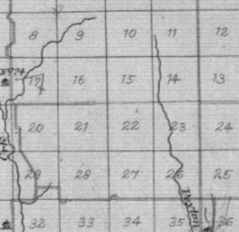
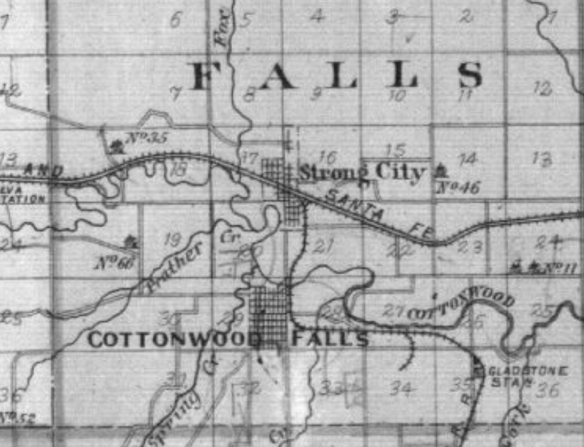
Opens grids like 21 and 28 depicted above would lead the audience to assume the land was just a flat plot without any obstacles or landmarks in or around it.
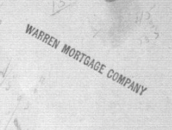
At the top of the map the words “Warren Mortgage Company” lead me to find that this map was an advertisement and used as a tool to help sell these plots of land. It also helps explain why the detail of the map is very simple. This map is not intended to be a navigational map to lead the audience but to show the audience the availability of land plots in the county in the early 1900’s.
The Chase County area was also written about in a way to fill in these blank spaces in William Least-Heat Moon’s PrairyErth (A Deep Map).
Least- Heat Moon’s PrairyErth holds quotes about and accounts from the Chase County area that detail the land and how it is more than just empty plots on a map. While maps like the 1901 account by the Warren Mortgage Company can be helpful for audiences looking to buy land and settle in the Chase County area, it is important to note that it does not display the fullness and detail of each inch of land.
Riley Filipowicz Blog Post 1
I noticed a few things when I first took a look at this map. I notice it is an outline of Chase County which is located in central Kansas. It was created in 1901 and looks to be owned by the Warren Mortage Group. When I realized this map was either created or sponsored by a mortgage company a lot more really stood out to me. The key includes things like houses, post offices, and churches. A mortgage company is obviously trying to sell and promote areas in Chase County to new or potential buyers.
Westward expanision was easier than ever in 1901 and this map shows that. I think the mortgage group is trying to use the map to show what areas were heavily populated and what they had to offer. For example, Cottonwood falls looks to have tons of habited areas. That can be shown by looking at the map and noticing all the figures placed there. I also think the railroad going through this area further strengthens that this was a heavily populated spot in Chase County.
I think this map could further convey its message by possibly showing a prediction of what this area is going to look like. It could also show suggestions from the Warren Mortage Company on what areas they think would be good to buy property.
Evan Murphy Blog Post 1: Mapped Interpretations of Chase County, KS
The Outline Map of Chase Co. Kansas. 1901 was created to attempt to increase settlement in the county in the southeast quadrant of the state. The scan of the map that was provided even contains a stamp of the Warren Mortgage Company seen below. The map’s purpose is to enable and convince people to settle in Kansas in the early 20th century, and holds little mention of the difficulties that may arise while attempting to cultivate the land.
This massively incomplete mapping interpretation of the prairie misinformed those who purchased plots of land, setting them up for failure. Those who purchased land in the great planes were ill equipped to farm in the region due to a shortage of information on the soil types and farming techniques that should be used. The quick sale of these and other similar plots of land in conjunction with lackluster information on how to farm the land likely aided in the severity of the Dust Bowl within Kansas a few decades after the creation of the map.
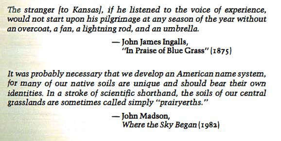
Although this type of map is important for the sale of land it lacks the fundamental understanding of the climate and soil needed for farmers to succeed in the region. William Least Heat-Moon created a more helpful sort of scientific historical collage map consisting of information provided by many different sources. This information was made available at different times, some of which was available before the 1901 map was created, but much of it was not. Although this information was publicly available, it was not all in one place. For example, these two quotes on the first page of the written map would have allowed for a more complete understanding of the gumption needed to cultivate land in Kansas.
Heat-Moon’s approach to mapping portrays a more complete view of the world through the combination of multiple sources. This provides an in-depth understanding of the climate and soil of southeastern Kansas that is difficult to convey to someone that has never been there. Overall, I feel as if Heat-Moon’s approach to mapping Chase County Kansas can be applied broadly to many parts of the great state. Had a map of this approach been available to potential settlers it certainly would have made them aware of the challenges they were going to undergo. This more complete and robust mapping attempt could have been helpful to settlers and reduced improper farming practices throughout the state of Kansas.